The dance indigenous to the Rajasthan region of India, specifically linked to the Kalbelia tribe, is recognized as Kalbelia dance. This traditional performance, alternatively referred to as 'Sapera Dance' or 'Snake Charmer Dance,' showcases the artistic expression of the Kalbelia community.
Notably, this dance and the associated melodies from Rajasthan gained global recognition, earning a spot on UNESCO's prestigious register of the Intangible Cultural Heritage of Humanity in 2010. Within the Kalbelia dance, male individuals engage with customary musical instruments, while the female members execute the choreography.
This dance form is notably regarded as one of the most captivating amongst all Rajasthani dances.
Origin and Significance of Kalbelia Dance
The origin of Kalbelia dance lies within the cultural heritage of the Kalbelia tribe residing in Rajasthan. Historically, these nomadic people led a migratory lifestyle, preferring mobility over permanent settlement.
The Kalbelia tribe was historically linked to snake-catching and the trade of snake venom, often recognized as Sapera or Snake Charmers.
The traditional Kalbelia folk dance predominantly features female performers, who synchronize their movements with the enchanting melodies of the Been, a traditional musical instrument.
This dance is an integral part of joyful occasions within the Kalbelia community. Unlike structured educational systems, formal manuscripts, or documented instructions, Kalbelia songs and dance routines are transferred through generations via oral tradition, maintaining the essence of this folk art alive.
Dams play a vital role in a country's water management system, including irrigation, flood control, hydroelectric power generation, and water supply. A clear understanding of the important dams in India, their geographical location, and associated rivers is essential for the UPSC Civil Services Examination.
Important Dams in India
Bhakra Nangal Dam
Located in Himachal Pradesh on the Sutlej River, Bhakra Nangal Dam is one of the highest gravity dams in the world. The dam's primary purposes include electricity generation and irrigation in Himachal Pradesh, Punjab, Haryana, and Rajasthan.
Hirakud Dam
Constructed across the Mahanadi River in Odisha, Hirakud Dam is one of the world's longest man-made dams. It is primarily used for irrigation, flood control, and power generation.
Tehri Dam
Tehri Dam, located on the Bhagirathi River in Uttarakhand, is the highest dam in India. It serves the dual purpose of hydroelectric power production and water supply for irrigation.
Sardar Sarovar Dam
Built on the Narmada River in Gujarat, Sardar Sarovar Dam is a part of the Narmada Valley Project. It provides irrigation facilities to Gujarat and Rajasthan, and electricity generation for four Indian states.
Nagarjuna Sagar Dam
Nagarjuna Sagar Dam, constructed on the Krishna River, lies between Telangana and Andhra Pradesh. The dam provides irrigation water to the Nalgonda, Prakasam, Khammam, and Guntur districts.
Indira Gandhi Canal
Although not a dam, it's crucial to mention the Indira Gandhi Canal, which originates from the Harike Barrage at the confluence of the Beas and Sutlej rivers in Punjab. This canal system is one of the largest in India and primarily provides irrigation in the Thar Desert region of Rajasthan.
Tungabhadra Dam
Tungabhadra Dam is built on the Tungabhadra River, a tributary of the Krishna River. Located in Karnataka, the dam provides irrigation and hydroelectricity to parts of Karnataka and Telangana.
Dam
Location
Bhakra Nangal Dam
Himachal Pradesh
Hirakud Dam
Odisha
Tehri Dam
Uttarakhand
Sardar Sarovar Dam
Gujarat
Nagarjuna Sagar Dam
Andhra Pradesh & Telangana
Indira Gandhi Canal
Rajasthan
Tungabhadra Dam
Karnataka
What is the largest dam in India, and what are its key features?
The Tehri Dam, located in Uttarakhand, is the tallest dam in India. It serves multiple purposes, including electricity generation, irrigation, and flood control, with a significant capacity for hydroelectric power production.
How do dams contribute to India's electricity supply?
Dams contribute significantly to India's electricity supply by harnessing the potential of hydroelectric power, a renewable energy source that plays a crucial role in the nation's energy mix.
What role do dams play in flood control and irrigation in India?
Dams are instrumental in controlling floods by regulating river flow and providing a reliable water supply for irrigation, supporting agriculture in various regions.
Conclusion
Understanding the importance and geographical location of key dams in India forms a crucial part of the UPSC Civil Services Examination syllabus, primarily under Indian Geography. Aspirants should keep themselves updated with recent developments related to these dams, their significance, and the challenges associated with them.
This knowledge will enrich their answers and perspectives in both the Preliminary and Mains stages of the examination.
Context: India’s Parliament passed a law allowing the government to auction and mine its newly discovered reserves of lithium, among other minerals, increasing the mining of the critical input for EV batteries.
The Mines and Minerals (Development and Regulation) Amendment Bill, 2023 amends the Mines and Minerals (Development and Regulation) Act, 1957.
The Act regulates the mining sector. For regulation, the Act classifies mining-related activities into:
reconnaissance, which involves a preliminary survey to determine mineral resources.
prospecting, which includes exploring, locating, or proving mineral deposits.
mining, the commercial activity of extraction of minerals.
Key features of the amendment bill:
Private sector involvement - It seeks grant of exploration licence to private sector players for deep-seated and critical minerals.
Reconnaissance to include sub-surface activities: The Act defines reconnaissance operations as operations undertaken for preliminary prospecting and includes: (i) aerial surveys, (ii) geophysical, and (iii) geochemical surveys. It also includes geological mapping. The Act prohibits pitting, trenching, drilling, and sub-surface excavation as part of reconnaissance. The Bill allows these prohibited activities.
Exploration licence for specified minerals: The Act provides for following types of concessions:
(i) a reconnaissance permit for reconnaissance,
(ii) a prospecting licence for prospecting,
(iii) mining lease for undertaking mining, and
(iv) a composite licence, for prospecting and mining.
The Bill introduces an exploration licence, which will be issued for 29 minerals specified in the Seventh Schedule.
These include gold, silver, copper, cobalt, nickel, lead, potash, and rock phosphate.
These also include six minerals classified as atomic minerals under the Act:
(i) beryl and beryllium, (ii) lithium, (iii) niobium, (iv) titanium, (v) tantallium, and (vi) zirconium.
The Bill declassifies them as atomic minerals. Unlike other minerals, the prospecting and mining of atomic minerals is reserved for government entities under the Act.
Exclusive auction mining lease to centre - It empowers the central government to exclusively auction mining lease and composite licence for certain critical minerals.
Time limits - Blocks explored by the exploration licence holder would be auctioned for mining lease within a prescribed timeline.
Merits:
Rationalization of minerals - Many of the minerals listed as atomic minerals have numerous non-atomic applications in space industry, electronics, technology and communications, energy sector, electric batteries etc. In most cases, the non-atomic uses of these minerals far outweigh their atomic use. Many such minerals are not fissile or radioactive in nature.
Reduced financial burden on government - Deep-seated minerals such as gold, silver, copper, zinc, lead, nickel, cobalt, platinum group of minerals, and diamonds are difficult and expensive to explore and mine hence involving them may reduce the financial burden on government.
Geopolitical advantage – It may reduce the dependence of India over the imports of such minerals thereby reducing the relative geopolitical vulnerabilities.
Increase in efficiency - Only 19 blocks of minerals have been auctioned so far by the State Government viz. graphite, nickel and phosphate out of 107 blocks handed over to the various State Governments. As these critical minerals are vital for the growth of our economy, authorizing the Central Government to auction concession for these critical minerals would increase the pace of auction and early production of the minerals.
Innovation in mining - Private participation will improve the scope of mining and innovation in this sector.
Improving revenue to states - Timebound auctioning will help state to have better revenues.
Boost to manufacturing- Reducing the government monopoly will eventually bring competition in this sector boosting the mining of such minerals which are very critical when it comes to E.V manufacturing, chip industries etc.
Issues involved :
Private participation may lead to misuse, irresponsible and excessive mining. This can have several detrimental socio-environmental implications.
Already stressed Public sector undertakings may further take the backseat.
Issue of federalism because of exclusive right to centre to auction mining lease.
The Bill also dispenses with cumbersome forest clearances for mine reconnaissance and prospecting operations. This may affect the ecology of the concerned region.
Context:The Geographical Indications Registry in Chennai granted the Geographical Indication (GI) tag to seven products from different regions of India.
What is a GI tag?
Geographical Indications of goods refer to the place of origin of a product. GI tags are a form of Intellectual Property Rights (IPR) that convey an assurance of quality and distinctiveness, attributable to the fact of its origin in a specific geographical locality, region or country. E.g., Tirupathi laddu, Nagpur oranges.
The Department for Promotion of Industry and Internal Trade, Ministry of Commerce and Industry awards GI Tag in India.
A GI registration is given to an area, not a trader, but once a product gets the registration, traders dealing in the product can apply to sell it with the GI logo.
Any trader’s body, association, or organisation can apply for a GI tag. The applicants need to prove the uniqueness of the item with historical records and a complete breakdown of how the product is made.
Authorised traders are each assigned a unique GI number.
The raw materials for such products do not have to come from that region (unless it is an agricultural tag). E.g.,
Leaf in Banarasi paan is not grown in Varanasi; it comes from Bihar, West Bengal, or Odisha.
Mulberry silk used in Kancheepuram sarees comes from Karnataka and the gold zari from Surat.
If any unauthorised trader tries selling the product under that name, they can be prosecuted under The Geographical Indications of Goods (Registration and Protection) Act, 1999.
India, as a member of the World Trade Organisation (WTO) has enacted the Geographical Indications of Goods (Registration & Protection) Act, 1999 which came into force in 2003.
Under Articles 1 (2) and 10 of the Paris Convention for the Protection of Industrial Property, geographical indications are covered as an element of IPRs.
Categories of GI products:
There are over 500 GI tags as of January 7, 2023. There are 34 classes of products that can get GI tags, ranging from chemicals and paint to foodstuff, handicrafts, musical instruments, firearms, locomotives etc.
The products in the GI registry fall under five major categories (Chart 1). Handicrafts dominate the list, with over half the GI tags being given to products crafted by skilled artisans.
GI tags across States:
Every State in India has at least one GI tag which is a proxy for unique cultural items.
If a State has more GI tags compared to another, it does not necessarily mean that the state is more culturally rich; it just means that more items have been registered.
Tamil Nadu (61) has the highest number of GI tags compared to other States.
Uttar Pradesh (56) has the second highest number of GI tags.
Banaras offers 11 unique crafts and agricultural items (the highest from a single place), including the famous Banarasi paan.
Benefits of GI tags:
Prevents unauthorised use of GI tag products by others.
Helps consumers to get quality products of desired traits and is assured of the authenticity.
Promotes economic prosperity of producers of GI tag goods by enhancing their demand in national and international markets.
About the Products
Jalesar Dhatu Shilp (metal craft)
Jalesar is located in the Etah district of Uttar Pradesh and was the capital of Magadha King Jarasandha.
The metal art of Jalesar is highly esteemed for its intricate designs and exceptional craftsmanship, blending elements of both traditional and contemporary styles.
Skilled artisans employ various techniques such as casting, molding, hammering, engraving, and filigree work to create a diverse array of metal products.
Goa Mankurad mango
The mango was given the name ‘Malcorada’ by the Portuguese, which translates to ‘poor coloured’.
Over time, this word evolved into ‘Mankurad’ and in the Konkani language, it came to be known as ‘aamo’ which means mango.
Goan Bebinca
Bebinca, a traditional Indo-Portuguese dessert, is a type of pudding widely recognized as the ‘Queen of Goan desserts.’
Udaipur Koftgari metal craft
The ancient art of Koftgari is used to create exquisitely ornamental weaponry.
This damascene technique involves a complex process of etching designs, heating, and cooling the metal, while also embedding gold and silver wire into the surface.
Unlike inlaid metal ornamentation, the wire does not sink into the iron; instead, it remains on the surface and is mechanically bound through pressing, burnishing, and polishing.
After the design is complete, burnishing tools known as Opani are used to push and bind the overlaid silver firmly.
Lastly, the surface is polished using a hakek stone to achieve the final stunning appearance.
The term ‘Koftgari’ originates from the Persian and Urdu words 'kuft-gari,' meaning 'beaten work,' and the artisans who practice this art are called 'kuftgars' or gilders.
Historically, Koftgari was brought to India by Persian craftsmen during the 16th century when they served Mughal rulers.
The Mughal Emperors, had a significant iron workshop called the Mughal Silehkhana that produced ornamented swords and weapons for the imperial army.
Bikaner Kashidakari craft
The technique involves printing diverse patterns on fabrics through the tie and dye method.
The thread used in the embroidery varies from the finest silk to the thickest wool. It is often combined with glass, sequins, and various types of stitches to create rich and detailed patterns, typically worked in chain stitches.
The embroidery creates a captivating contrast between colours, with dramatic effects achieved through the use of vibrant traditional hues like yellow, black, red, and green.
Geometric forms are harmoniously balanced with depictions of trees, peacocks, and other motifs.
Jodhpur Bandhej craft
Bandhej is a popular traditional craft of Rajasthan, with Jodhpur being one of the prominent centres for this art form.
Bandhej patterns: Dot pattern known as Bandhani, the wave pattern called Leheriya, and even the Japanese motif called Shibori.
The art of Bandhej is primarily practiced by the skilled women artisans of the Rangrez community, meaning ‘dyer’ in Persian.
The process starts with preparing the fabric, which is typically cotton or silk. The fabric is thoroughly washed to remove impurities and then dyed in a base colour, often red, blue, green, or yellow.
Skilled artisans meticulously tie small, tight knots on the fabric using thread, creating various patterns like dots, squares, waves, or stripes.
After tying the fabric, it is immersed in a dye bath. The areas where the knots are tied resist the dye, resulting in a unique and mesmerizing pattern on the fabric.
Bikaner Usta Kala craft
The Bikaner Usta Kala craft is also known as gold nakashi work or gold manauti work, owing to the predominant use of golden colour in its exquisite designs, created with actual gold during the earlier periods.
It is a unique form of miniature painting practiced on metal surfaces.
The skilled artisans, known as ‘Ustads’, have inherited their craft techniques from their ancestors, and they have diligently preserved this art form through generations.
The metal surface is first cleaned and polished meticulously, providing a smooth and ideal canvas for the upcoming artwork.
To impart a distinctive shimmering effect, the designated areas of the artwork are adorned with a layer of gold or silver leaf.
Employing natural pigments and carefully selected colours, the Ustad adorns the artwork with intricate brushwork, creating a harmonious and vibrant appearance.
The motifs and themes often draw inspiration from Mughal and Persian influences, showcasing elaborate floral patterns, geometric designs, and captivating scenes from epics and mythology.
Context:Following the unveiling of the statue of 9th-century king Mihir Bhoja as 'Gurjar Pratihar Samrat Mihir Bhoja' by district party leaders, leaders in Haryana's Kaithal expressed their protest by offering to resign. The controversy surrounding Mihir Bhoja's lineage has arisen before in Bihar and Uttar Pradesh, with both Gurjaras and Rajputs laying claim to his belonging in their respective communities.
About Mihir Bhoja
Mihir Bhoja (836 to 885 CE), was a highly successful and ambitious ruler in ninth-century India. At that time, the Gurjara-Pratiharas held dominion over a vast empire, stretching from Kashmir to Gujarat.
Mihir Bhoj ascended to power after succeeding his father, Ramabhadra. He also expanded his influence by conquering regions in the Deccan and Malwa.
Tripartite Struggle:
During the ninth century, a major political struggle centered around gaining control of Kannauj, as it was believed that whoever ruled there would become the emperor of the country.
This led to a tripartite conflict among the powerful entities of the time—the Gurjara-Pratihara, the Rashtrakutas of Deccan, and the Palas of Bengal. Among them, Mihir Bhoj emerged as the most successful.
He secured territories of Gujarat and Malwa from the Gujarat-Rashtrakutas and further expanded his realm by conquering areas of Gorakhpur from the Palas of Bengal.
He was a devout follower of Vishnu and used the title of Adivaraha, which was inscribed on some of his coins.
His rule spanned a vast territory, from the foothills of the Himalayas to the Narmada River, which included the present district of Etawah in Uttar Pradesh. Kannauj, which served as his capital during his reign, was known as Panchala.
Mihir Bhoja was a staunch adversary of the Arab invaders and maintained a formidable army, particularly renowned for its skilled cavalry. Following his rule, his son Mahendrapala I succeeded him.
Lineage:
Originally, the Gurjars were a nomadic tribe in ancient India, initially spread across the regions of Rajasthan and Gujarat, and it is believed that Mihir Bhoja belonged to this tribe.
However, historical records also suggest that he asserted Kshatriya status for himself. It was a common practice in ancient India for kings to claim Kshatriya lineage, as it was considered that only a Kshatriya (warrior) could rightfully ascend to the throne.
The controversy surrounding the castes of ancient rulers in recent times is primarily a product of modern-day politics and does not have any direct bearing on historical accuracy.
It is essential to approach these historical accounts with a critical perspective, considering the societal context and the evolution of social identities over time.
Military Career
Mihira Bhoja first consolidated his territories by crushing the rebellious feudatories in Rajasthan, before turning his attention against the old enemies the Palas and Rastrakutas.
He invaded the Pala Empire of Bengal but was defeated by Devapala. He then launched a campaign to conquer the territories to the south of his empire and was successful, thus Malwa, Deccan, and Gujarat were conquered.
The Pratiharas were defeated in a large battle in Ujjain by Rastrakutas of Gujarat however, retribution followed on the part of the Pratiharas, and by the end of his reign, Bhoja had successfully destroyed the Gujarat Rashtrakuta dynasty.
Bhoja's feudatory, the Guhilas chief named Harsha of Chatsu, is described as defeating the northern rulers with the help of the mighty elephant force, and loyally presenting to Bhoja the special ‘Shrivamsha’ breed of horses, which could easily cross seas of sand.
Besides being a conqueror, Bhoja was a great diplomat. The Kingdoms which were conquered and acknowledged his suzerainty include Travani, Valla, Mada, Arya, Gujaratra, Lata Parvarta, and Chandelas of Bundelkhand.
Bhoja's Daulatpura-Dausa Inscription, confirms his rule in the Dausa region. Another inscription states that ‘Bhoja's territories extended to the east of the Sutlej River.’
Kalhana's Rajatarangini states that the territories of Bhoja extended to Kashmir in the north, and Bhoja conquered Punjab by defeating the ruling ‘Thakkiyaka’ dynasty.
Coins of Mihira Bhoja
Mihira Bhoja was commonly known by the epithet ‘Srimad-Adivaraha’, which refers to the fortunate primeval boar incarnation of Vishnu.
These coins feature a depiction of Adivaraha on the obverse side, where the God holds a solar wheel with spokes in his right hand, while in his left hand, there are other emblems such as a mace, lotus flower, and conch shell.
Additionally, under the feet of God, there is likely a two-headed serpent. According to Alexander Cunningham, these types of coins are found in both silver and copper.
It is believed that copper coins were originally coated with silver to circulate as silver coins. The presence of Adivaraha coins was noted by Thakkar Pheru in the 13th-century text ‘Dravya-Pariksha,’ who served as a mint master under Alauddin Khilji.
Gurjara-Pratihara Empire
The Gurjara-Pratiharas, also known simply as the Pratiharas, ruled over western and northern India from the 8th century CE to the 11th century CE.
This dynasty witnessed a significant rise in its fortunes under the rule of Nagabhata I (730–760 CE), who successfully repelled Arab invaders.
The Pratiharas were particularly known for their generous patronage of art, sculpture, and temple construction.
Rudragiri hillock located in the Guntur district of Andhra Pradesh, boasts a celebrated historical past and remarkable archaeological monuments. This site unveils a fascinating combination of prehistoric rock paintings from the Mesolithic period and exquisite artwork from the Kakatiya dynasty.
More about the news
At the foothills of Rudragiri, five naturally formed rock shelters have been uncovered.
These shelters served as dwellings for people during the Mesolithic age approximately around 5000 B.C. They contain striking rock paintings from that era, which provide a fascinating glimpse into the past.
Two of these natural caves display remarkable murals dating back to the renowned Kakatiya dynasty. Despite being affected by the forces of nature over time, fragments of these paintings offer valuable insights into their creation during the 13th century A.D.
The paintings are adorned with a variety of colors derived from white kaolin and various pigments. They vividly depict captivating scenes from the epic Ramayana.
In the first cave, there is a narrative mural portraying the intense battle between the Vanara brothers - Vali and Sugriva.
The middle cave features a grand sketch of Hanuman, accompanied by sacred symbols such as the conch (Sankha) and the fire altar (Yagna Vedi).
Additionally, the third cave houses prehistoric rock paintings dating back to the Mesolithic era, providing a glimpse of the ancient artistic expressions from that time.
Early Rock Paintings in India
India boasts some of the earliest rock paintings dating back to the Upper Palaeolithic times.
The first discovery of rock paintings in India was made by archaeologist Archibold Carlleyle.
Remnants of these ancient paintings have been found on cave walls in several districts of Madhya Pradesh, Uttar Pradesh, Andhra Pradesh, Karnataka, Bihar, and even the Kumaon hills in Uttarakhand, particularly at Lakhudiyar, where the rock shelters along the River Suyal preserve these prehistoric artworks.
The Spectacular Rock Shelters of Bhimbetka
One of the most remarkable sites of rock paintings in India is Bhimbetka, located in the Vindhya hills of Madhya Pradesh.
Discovered by archaeologist V.S. Wakankar.
The paintings at Bhimbetka depict a diverse range of themes, including daily life events, sacred and royal images, hunting scenes, dancing, music, horse and elephant riders, animal fights, honey collection, body decoration, and household scenes.
Classification of Bhimbetka Rock Art
The rock art at Bhimbetka has been categorized into various groups based on style, technique, and superimposition.
The drawings and paintings are classified into three historical periods: Period I (Upper Palaeolithic), Period II (Mesolithic), and Period III (Chalcolithic).
Mesolithic Paintings
During the Mesolithic period (Period II), the rock paintings at Bhimbetka feature a variety of themes, with hunting scenes being predominant.
The paintings depict groups of primitive men hunting animals with barbed spears, pointed sticks, arrows, and bows.
Some paintings show the hunters using traps and snares to catch animals. The hunters are depicted wearing simple clothes and ornaments, occasionally adorned with elaborate headdresses or masks.
The Mesolithic artists showed a mix of fear and tenderness for animals in their artwork.
Daily Life Depictions
The rock paintings at Bhimbetka also depict various aspects of daily life during the Mesolithic era.
Scenes of community dances, people gathering fruits or honey from trees, and women grinding and preparing food are common themes.
The artists painted men, women, and children engaged in various activities, giving a glimpse of what life was like for these ancient people.
Techniques and Colours
The artists at Bhimbetka used a wide range of colors, including white, yellow, orange, red ochre, purple, brown, green, and black.
White and red were particularly favored colors.
The paints were made by grinding various rocks and minerals, such as haematite for red and chalcedony for green.
The artists used plant fiber brushes for their artwork.
Surprisingly, these colors have survived thousands of years due to the presence of oxide on the rock surface, which helped preserve the paintings despite adverse weather conditions.
Location and Purpose of Paintings
The paintings were made on the walls and ceilings of rock shelters, with some found in places where people lived and others in areas with potential religious significance.
The elevated locations of some paintings suggest they were meant to be visible from a distance.
The paintings display pictorial quality and provide insights into the lives and beliefs of early human beings, showing a passion for storytelling and a portrayal of humans and animals engaged in the struggle for survival.
A Glimpse into Prehistoric Life
These prehistoric paintings offer valuable information about early human beings, their lifestyle, food habits, and daily activities.
They provide a glimpse into the minds of these ancient artists, reflecting their thoughts and perceptions.
The remains from the prehistoric period, including rock weapons, tools, ceramics, and bones, serve as witnesses to the evolution of human civilization, with the rock paintings being among the most significant legacies left behind by the primitive humans of that time.
About Kakatiya Dynasty
Early Kakatiya Dynasty rulers
The Kakatiya dynasty, known for ruling the eastern Deccan region from the 12th to the 14th centuries, had its roots traced back to Venna, who reigned from 800 to 815 AD.
Venna was believed to be a descendant of Durjaya, a legendary chieftain of the Andhra kingdom.
The Kakatiya lineage continued with Gunda I and Gunda II, about whom little information is available except for their rule from 815 to 865 AD.
During the early days, the Kakatiyas served as vassals to the powerful Rashtrakuta, which held significant influence over much of India during the 6th to 10th centuries AD.
Rise to Power and Independence
After the collapse of the Rashtrakuta kingdom, Gunda IV saw an opportunity to establish his family's independent rule.
He declared Kuravi as an independent principality, leading the Kakatiya dynasty towards self-governance.
Consolidation and Expansion
Ganapati, who ruled from around 1199 to 1262, focused on consolidating the kingdom and expanding its territories.
He led successful campaigns, bringing Telugu-speaking lowland deltas around the Godavari and Krishna rivers under his control.
The capital of Kakatiyas was Orugallu, now known as Warangal.
Rudrama Devi: A Remarkable Female Ruler
Rudrama Devi, succeeding Ganapati, was one of the few female rulers in Indian history.
She continued her predecessor's fortification efforts and repelled an attempted invasion by the Seuna dynasty (Yadava Dynasty).
She married an Eastern Chalukyan prince, Virabhadra, and later handed over the throne to her grandson, Prataparudra II.
Decline of the Kakatiya Dynasty
Prataparudra II faced challenges from the Delhi Sultanate under Alauddin Khalji, who saw the wealth and potential of the Kakatiya lands.
Prataparudra II initially submitted to Alauddin but later asserted his kingdom's independence.
The subsequent conflicts with the Delhi Sultanate led to the fall of the Kakatiya dynasty.
Context:Several events have been scheduled to commemorate the 200th anniversary of Nawab Wajid Ali Shah, the final ruler of Awadh, who possessed a remarkable appreciation for the arts. These activities comprise an exhibition, a heritage walk, and informative discussions.
About Nawab Wajid Ali Shah
Mirza Wajid Ali Shah, the final ruler of Awadh, held the position from 1847 to 1856.
His second wife Begum Hazrat Mahal, played a significant role in the Indian Rebellion of 1857 against the British East India Company, acting as the regent of Awadh.
Although his kingdom had been safeguarded by the East India Company under a treaty, it was annexed by the company in 1856.
Following the annexation, the Nawab was exiled to Metiabruz, a suburb of Kolkata, where he spent the rest of his life receiving a generous pension.
Wajid Ali Shah was not only a ruler but also a poet, playwright, dancer, and avid patron of the arts. He introduced Kathak, a significant form of classical Indian dance, as a court dance during a period when the Mughal influence was diminishing, primarily for recreational purposes.
As a Ruler of Awadh
The British East India Company had already annexed a significant portion of Awadh through a treaty signed with the Nawabs in 1801.
The company's actions had severely impacted the Awadh economy by burdening it with the costs of maintaining the Bengal Army and repeatedly demanding loans.
Wajid Ali Shah became the ruler of Awadh when the East India Company was determined to annex the prosperous kingdom, which was regarded as "the garden, granary, and queen-province of India."
Upon ascending the throne, he actively participated in the administration of justice, implemented reforms, and reorganized the military.
The British Resident of Lucknow, General William Sleeman, submitted a report highlighting alleged "maladministration" and "lawlessness" in Awadh. This report conveniently provided the British with the justification they needed for the annexation under the Doctrine of Lapse by Governor-General Lord Dalhousie.
Patronage to Music
Wajid Ali Shah patronized music, dance, drama, and poetry, but he was also a gifted composer himself.
Bahadur Hussain Khan, was one of Wajid Ali Shah's favorite musicians. The Nawab honored him with the title Zia-ud-Daulah.
He adopted the pseudonym ‘Akhtarpiya’ for his musical compositions. Under this name, he wrote poems, prose, and thumris.
His collections, Diwan-i-Akhtar and Husn-i-Akhtar, contain his ghazals.
Much of the knowledge about music in Nawabi Lucknow comes from the text Madanul Moosiqui ('The Mine of Music').
During his reign, complex ragas like hori and dhrupad were less emphasized, while easier raginis like tilak, pilu, sendura, khammach, bhairvi, and jhanjhauti gained popularity.
These raginis were favored by the king and easily understood by all sections of society, making them beloved by the common people.
There is a popular belief that Wajid Ali Shah was the creator of the light classical form known as thumri.
Wajid Ali Shah's innovative ideas and experiments in ghazals played a significant role in shaping the modern-day style of ghazals.
Patronage to dance
In ancient times, Kathak was originally performed as part of temple rituals.
It was under the artistic guidance and patronage of Nawab Wajid Ali Shah that Kathak reached new heights.
During this period, Kathak was also extensively performed by courtesans, who developed the art form alongside its refinement in the court.
Their style of Kathak differed from the court style, often incorporating playfulness known as nakhra.
Wajid Ali Shah introduced two distinct forms of Kathak: Rahas and Raas.
Rahas was a choreographed dance form that incorporated acting, dancing, and music. It encompassed dramatic elements and portrayed different scenes, often with changing settings and locales.
On the other hand, Raas was a religious form of Kathak.Dhrupad, a form of classical music, was primarily sung during Raas performances, which began with its singing.
It was during Wajid Ali Shah's reign that the Lucknow Gharana of Kathak emerged. The Lucknow style of Kathak is characterized by graceful movements, elegance, natural poise, and a focus on abhinaya (expressions).
Wajid Ali Shah made Kathak the official court dance and also popularized it among the people.
Contributions to literature
The famous poet Mirza Ghalib received gracious patronage from Wajid Ali Shah.
Wajid Ali Shah himself was a prolific writer, utilizing a simple language that conveyed meaning to all, often incorporating Awadhi, the local dialect.
His most significant work, Sawat-ul-Qalub, comprises a collection of 44,562 couplets.
Among his notable works, the autobiographical Huzn-i-Akhtar holds great importance. It portrays the unfavorable and unceremonious treatment he faced at the hands of British authorities.
Another significant work by Wajid Ali Shah is Bani. It serves as a treatise on Music and Dance, offering insights into the mushairas (poetic gatherings) held at Matiya Burj (Calcutta).
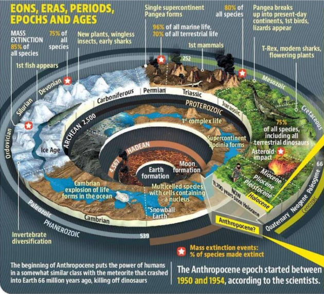
Context:A group of scientists have identified a small lake in Canada as the ground zero for ‘Anthropocene’.
What is Anthropocene?
It is an unofficial unit of geologic time which is used to denote the most recent period in Earth’s history when human activity started to have a significant impact on the planet’s climate and ecosystems, especially since the onset of the Industrial Revolution.
Neither the International Commission on Stratigraphy (ICS) nor the International Union of Geological Sciences (IUGS) has officially approved the term as a recognised subdivision of geologic time.
This term was first coined by Nobel Prize – winning chemist Paul Crutzen and biology professor Eugene Stoermer.
The phenomena’s which are associated with this geological time are global warming, sea-level rise, ocean acidification, mass-scale soil erosion, heat waves, deterioration of the biosphere and other detrimental changes in the environment.
Context:India's population has skyrocketed from 340 million at Independence to 1.4 billion, thanks to improved public health and medical advancements. This unexpected decline in mortality has transformed the lives of Indians, especially women, as they navigate longer lifespans and the consequences of fewer children.
Demographic transition
Demographic transition refers to the process of changes in population characteristics that occur as societies develop over time.
India’s Demographic transition
The growth of population was fuelled by receding starvation, improved public health and medical interventions.
In 1941, male life expectancy was about 56 years and only 50% of boys survived to age 28. Today, life expectancy for men is 69 years and nearly 50% of them live up to 75 years of age.
Due to rapid decline in mortality rates, the Total Fertility Rate (TFR) fell from 5.7 in 1950 to 2.1 in 2019. #As per National Family Health Survey 5
Dynamics of Male Child in India
Social norms and patrilocal kinship patterns combined with lack of financial security reinforce a preference for sons.
According to India Human Development Survey (IHDS), 85% of women respondents expected to rely on their sons for old age support, while only 11% expected support from their daughters. #Report
Nowadays, Parents who want to ensure at least one son among their one or two child family, often resort to sex selective abortion.
Impact of declining fertility on Women’s life
Increased opportunities for Education: With declining fertility, women may choose to delay starting a family in order to pursue education, career goals, or personal aspirations. This can provide women with greater opportunities for personal and professional growth. In India, there has been significant progress in women's educational attainment, with over 70% of girls enrolling in secondary education.
Focus on family planning: Declining fertility rates often coincide with increased availability and acceptance of family planning methods. This empowers women to have greater control over their reproductive choices, allowing them to plan the timing and number of children they want to have.
Reduce gender disparities in society: When women have fewer children, they can allocate more time and energy towards their own pursuits, including education, careers, and personal interests. This can help break traditional gender roles and promote gender equality by challenging societal expectations placed on women as primary caregivers.
Improved employment opportunities: With fewer children to care for, women can participate more actively in the labour force, contributing to household income and economic growth. Women's financial independence can lead to greater decision-making power within families and promote their overall well-being.
Reduced maternal and infant mortality: When women have fewer pregnancies, the overall risk of complications and health issues associated with childbirth is reduced. Improved access to healthcare services, prenatal care, and skilled birth attendants further enhances maternal and infant health outcomes.
How early marriage and aging impacts Women’s empowerment?
Early motherhood may not lead to increased participation in the labour force for women. By the time their childcare responsibilities decrease, they may have missed out on opportunities in occupations that require specialized skills, leaving them with limited options for employment, mostly in unskilled work.
For widowed women, the lack of access to savings and property results in dependence on children, mainly sons, bringing the vicious cycle of son preference to full circle.
Practical strategies to harness Gender Dividend:
Enhancing women’s access to employment and assets will reduce their reliance on sons and could break the vicious cycle of disadvantage, stretching from childhood to old age.
Expansion of anganwadis to include a creche can result into increased participation of mothers in the work. E.g., Randomised control trial in Madhya Pradesh showed positive results as per World Bank.
State support should be provided for childcare, as it creates space for education and employment for Women. #CaseStudy: State support for childcare declined, employment rates for mothers fell from 88% to 66% in urban China.
Government can make staffing creche an acceptable form of work under National rural employment guarantee scheme (NREGS).
Self-help group movement can be harnessed to setup neighbourhood childcare centres in urban and rural areas.
Fully harnessing the gender dividend is crucial for realizing the long-awaited demographic dividend, and a significant aspect of accomplishing this is by ensuring optimal access to childcare.
Context:The President of India Droupadi Murmu paid tribute to Alluri Sitarama Raju, the freedom fighter at the closing ceremony of his 125th birth anniversary celebrations in Hyderabad.
About Alluri Sitaram Raju
Alluri Sitaram Raju was an influential Indian revolutionary who played a significant role in the country's struggle for independence.
Born on July 4, 1897, in a modest middle-class family near the Coastal city of Visakhapatnam, Raju developed a strong sense of patriotism from an early age.
His dedication to the freedom movement and his efforts to improve the lives of the Adivasi communities left a lasting impact on Indian history.
Advocating for Adivasi Rights and the Freedom Struggle
However, these measures failed to alleviate their suffering. Determined to make a difference, Raju decided to reside in the Adivasi areas of the Eastern Ghats, specifically the forest region along Visakhapatnam and Godavari districts.
He dedicated himself to the Adivasis, who were living in dire poverty and facing exploitation by the police, forest officials, and revenue authorities. Raju provided much-needed support to the Adivasis through education and medical assistance, utilizing the knowledge he acquired during his extensive travels.
This region became the epicentre of his fight against the British rule. Raju learned from the Adivasis and combined their time-tested war methods with his own tactics, creating a formidable resistance against the British.
In August 1922, he launched the Rampa Rebellion, gaining substantial local support and successfully evading British authorities for an extended period.
British Response
Raju's armed struggle against the British frustrated the authorities to such an extent that they offered a reward for his capture, dead or alive.
Meanwhile, the British continued to inflict misery on the Adivasis. Seeking justice and fairness, Raju eventually surrendered, hoping for a fair trial in return.
However, on May 7, 1924, he was treacherously trapped and shot dead.
Legacy
Recognizing his courage and indomitable spirit, he was bestowed with the title "Manyam Veerudu" (Hero of the Jungle).
Every year, on July 4th, the Government of Andhra Pradesh commemorates his birth date as a state festival, honoring his contributions to the nation's freedom struggle.
The Rampa Rebellion:
The Rampa Rebellion, also known as the Manyam Rebellion, was a significant tribal uprising led by Alluri Sitarama Raju in the Godavari Agency of Madras Presidency, British India.
Spanning from August 1922 to May 1924, this rebellion marked a critical chapter in the fight against British colonial rule.
The Rampa administrative area, encompassing approximately 700 square miles, was home to around 28,000 tribal inhabitants. These tribes relied on the ‘podu system’, where they burned sections of the forest each year for cultivation, ensuring their food requirements were met.
However, the British authorities sought to exploit the lands of the Godavari Agency for commercial purposes, disregarding the needs of the tribal communities.
With the implementation of the Madras Forest Act in 1882, the Adivasis' free movement in their forest habitats was restricted, preventing them from practicing their traditional podu agricultural methods.
The tribal people faced starvation as their economic situation deteriorated, exacerbated by forced labor demands for road construction and perceived biases in the legal system.
Convergence of Discontent
Simultaneously, the muttadars, who had been hereditary tax collectors and rulers in the hills, experienced discontent due to their loss of power and status under British rule.
Previously acting on behalf of the rajas, the rulers of the plains, the muttadars found themselves marginalized and controlled by the colonial administration.
Their shared grievances with the tribal hill people created a common ground for resistance against the British.
Alluri Sitarama Raju's Leadership
He harnessed the discontent of the tribal communities, combining anti-colonial zeal with accommodation for sympathetic muttadars.
Raju's followers comprised primarily tribal members, but he also garnered support from influential individuals within the muttadar class.
While some muttadars remained ambivalent, Raju's overarching vision of liberation from colonial rule united these disparate groups.
The Rebellion
The rebellion commenced in August 1922, taking the form of guerrilla warfare.
The tribal fighters, adept at navigating the challenging terrain, proved resilient against British suppression efforts.
The prevalence of diseases in the region, to which the tribal people had developed immunity, further hindered the colonial authorities' attempts to quell the rebellion.
The Rampa Rebellion, led by Alluri Sitarama Raju, stands as a testament to the determination of tribal communities and their fight against British colonial rule. This uprising highlighted the grievances caused by the imposition of laws that restricted traditional practices and disrupted the economic stability of the Adivasis. Although the rebellion ultimately faced suppression, it left a lasting impact on the collective memory of the struggle for independence in India.
Context: India’s G20 Sherpa, stressed at a recent Urban-20 City Sherpas’ meet that a master plan is crucial for any city to manage urbanisation.
About Master Planning
It is an instrument of governance for urban local bodies (ULBs).
It is a statutory plan document, prepared for stream-lining the land use within the delineated planning area.
It is a long-term plan that provides a conceptual layout for future urban growth and development.
It includes analysis, recommendations, and proposals for a site’s population, economy, housing, transportation, community facilities, and land use.
It is based on public input, surveys, planning initiatives, existing development, physical characteristics, and social and economic conditions.
The validity of a Master Plan is for a specific period and after the expiry of the period it needs revision and modifications.
During the 11th Five-Year Plan, it was proposed to prepare Master Plan for priority towns and growth centers.
Recently, most States/UTs have revised their respective bye-laws based on the Model Building Bye Laws 2016 (MoHUA, 2016). It is imperative that the city governments adapt the model regulations and as per their context and economic growth drivers.
The powers to prepare master plans remain with State governments.
Significance of Master Planning
Growth & development of the city: It helps ULBs in achieving integrated development by considering various aspects such as land use, transportation, infrastructure, housing, environment, and social amenities.
Efficient land utilisation: It enables efficient land utilisation by identifying suitable areas for different purposes, and preventing haphazard development.
Infrastructure planning: It assists ULBs in identifying the infrastructure requirements of the city or town, such as roads, water supply, sewage systems, etc. to support the growing needs of the population and economic activities.
Environmental Sustainability: It incorporates environmental considerations and sustainability principles into the development process to foster a greener and more resilient urban landscape.
Disaster Resilience: It helps ULBs in incorporating measures to enhance the resilience of cities and towns to natural disasters, such as floods, earthquakes, and cyclones by identifying vulnerable areas, designing appropriate infrastructure, and implementing disaster risk reduction strategies.
Social equity: It takes into account the social aspects of urban development for the economically disadvantaged, provision of basic services to marginalized communities, and accessibility for people with disabilities to create inclusive cities where all residents have access to essential services and opportunities.
Challenges
Rapid Urbanisation: Many cities and towns are experiencing rapid population growth and urbanization, which can strain existing infrastructure and resources. Managing this rapid growth and ensuring that the master plan can accommodate future needs is a significant challenge.
Limited Resources: ULBs often face financial and resource constraints, making it challenging to implement comprehensive master plans.
Inconsistencies in decision-making: Frequent changes in political leadership, lack of continuity in governance, and bureaucratic challenges can hinder the execution of the master plan and result in inconsistencies in decision-making.
Data and Information Management: Limited capacity for data collection, data quality issues, and inadequate technology infrastructure can hinder the planning process.
Informal Settlements and Slums:Integrating these areas into the master plan and providing adequate housing, basic services, and infrastructure to these marginalized communities can be a complex and challenging task.
Environmental Concerns: Balancing urban development with environmental sustainability is a critical challenge.
Implementation and Monitoring: Monitoring progress, assessing the impact of implemented projects, and adapting the plan as needed are important but often challenging tasks due to limited capacity, coordination issues, and institutional barriers as per the NITI Aayog Report 2021.
No statutory backing: Some city governments lack much authority while some city administrations have developed mitigation plans without statutory backing. For example Bengaluru has not had a master plan to control its development and the Mumbai plan lacks any statutory backing and does not prescribe any regulatory controls.
Urban Planning: It is the State subject and as per the 12th schedule of the Constitution and the function of Urban Local Bodies / Urban Development Authorities but the state government has powers to prepare master plans.
Way forward
The Ministry of Housing and Urban Affairs has recommended that master plans in cities should be revisited for the improved governance of cities. The National Mission for Clean Ganga has been advocating such a step to protect urban water bodies.
Many plans to improve sanitation, infrastructure, and social inclusion are dependent on particular programmes, but these are at best ephemeral and incremental as they are centrally funded.
It is simply a spatial plan of land-use allocation supported by bye-laws and development control regulations. Thus, it essentially embodies a spatial vision for cities.
The era of planetary urbanisation brings spatial planning into sharp focus, and calls for reimaging the spatial planning framework in India.
Recent moves such as Gati Shakti and Model Rural Transformation Acts are a reflection of this growing demand. The Centre must work with the States to reconsider the spatial planning framework in India.
The Advisory Committee of Niti Aayog recommends a National Council of Town and Country Planners to be constituted as a statutory body of the Government of India.
Context: The Central Water Commission under Ministry of Jal Shakti organized a one-day national workshop on ‘Integrated Management of Sediments in River Basins and Reservoirs for Sustainable Development” at India International Centre in New Delhi. It was largely agreed that short and long term action plans need to be prepared along with measures to control silt deposition in Reservoir which may be implemented in phases.
What are sediments?
Sediment is a naturally occurring material, organic and inorganic, that is moved and deposited in a new location by water, wind or ice.
It is broken down and transported by processes of weathering and erosion.
They can consist of rocks, minerals, remains of plants and animals.
It can be as small as a grain of sand or as large as a boulder.
Sediment that is light enough to be carried by water without touching the stream bed is called suspended sediment.
Sediment created and deposited by glaciers is called moraine.
What is siltation and sedimentation?
Rivers flowing in the alluvial plains tend towards a stable flow condition. In other words, they try and maintain a balance between the silt load carried and the volume and velocities achieved by the flow. This is usually called a stable sediment regime for the river.
When the core parameters of volume and velocities are disturbed, either due to a low gradient (while it enters the plains) or encroachment in flood plain, widening of the channel (braiding of river streams) suspended silt particles in the river water settle down. This is called siltation.
This phenomenon is normally called sedimentation when it occurs in a reservoir.
Why sediments are important?
Source of nutrients: Sediment is important because it usually enriches the soil with nutrients forming large fertile plains. Areas rich in sediments are often also rich in biodiversity. The rivers lacking in sediments (mostly downstream rivers of dams,) are known as ‘hungry waters’.
Landform development: Sediment deposition create several landforms like natural levees, embankments, deltas and river banks, flood plains beaches, spits and sand bars etc.
Ecological functions: Sediment processes are an extremely important part of many ecosystems as well as of primary importance to particular species. For example, various organisms in both marine and freshwater environments rely on replenishment of sediment for their reproductive habitat.
Natural water filtration: When water passes through soil, it is cleaned via physical, chemical and biological processes. In addition to soil's physical filtration capacity, soil contains important biota that helps transform and decompose certain chemicals and other contaminants from soil, thus helping filter them out of the water.
Disaster management: Sediment is one of the main tools in coastal zone management. Huge amounts of sediment are being used for flood protection (e.g. beach nourishment), and habitat and wetland protection.
Following chart can help us to analyse the role of sediments in various spheres;
What is the effect of sand mining on sedimentation in rivers?
Mining of sand, if done at an optimum level, removes excessive sediment deposit in rivers.
Unscientific and excessive sand mining depletes the mineral at rates at which the river system cannot replenish it.
Excessive mining creates high over banks with steep slopes, which are not stable due to the limited shear strength of the constituent soil materials.
Continued collapse of such banks leads the river course to deviate towards developed lands and poses an ever-increasing threat to them.
What are the causes of reservoir sedimentation ?
Generally, soil erosion is the major cause of reservoir sedimentation and subsequent sedimentation of reservoirs is a complex process dependent upon a number of natural and anthropogenic factors.
The causes are classified into two with respect to the factors, namely;
Natural Causes
Geomorphology - configuration of the land surface including the location, size and shape of such physical features as hills, ridges, valleys, streams and lakes.
Hydrology - To be successful, a dam and reservoir project must have an adequate and continuous supply of water. The annual rainfall, the ratio of watershed area to reservoir area, and the volume of stream of the year must be known.
Hydrogeology - to determine whether groundwater would contribute to the reservoir or whether the reservoir would lose water to the groundwater system is also essential.
Soil characteristics - The type of soil and its properties such as porosity and permeability can cause or lead to erosion within and around the reservoir.
Anthropogenic Causes
Tillage practices: Wrong tillage practices can cause loose soil thereby leading to washing away of top soil.
Overgrazing: Too much grazing of vegetation by animals can lead to exposure of the soil in an area thereby causing erosion.
Mining and logging: Mining activities can lead to erosion due to wearing off of the surface through surveys and excavation as well.
What are the problems with sedimentation in dams?
Reduction of storage capacity: When a river is put to halt behind a dam, the sediment it contains settles at the bottom of the reservoir. Reservoirs have become settling tanks for the sediment in most cases. This means the dam has less and less space for water, which it was supposed to hold.
Impact on stability: Higher siltation of reservoirs exerts pressure on the reservoir thereby compromising the dam stability.
Reduced efficiency of power generation: The high rate of reservoir sedimentation pose a challenge to dam operators due to the abrasion of turbines and other dam components. The cracking of the tips of turbine blades by waterborne sand and silt considerably reduce their generating efficiency and needs costly repairs.
Reduced discharge capabilities: Sediments will often block low-level outlets designed to allow for reservoir drawdown. Reduction of spillway capacity can occur as a result of the loss of approach depth when the sediment front reaches the dam.
Environmental impacts: Plant and animal species are sensitive to alteration of both the sediment supply and flow regime. Increases in sediment concentration in upstream areas can create turbid waters with a smaller euphotic zone. This decreases plant productivity, negatively impacting fish and bird species and can also cause visual impairment for predatory fish, affecting their feeding habits. Finally, sediment is a primary carrier of suspended pollutants such as nitrogen, phosphorous and heavy metals. Sediments released as a result of sediment management or a dam breach may have environmental effects that can persist for decades.
In India, government statistics on 11 of the country’s reservoirs with capacities greater than one cubic kilometre show that all are filling with sediment faster than expected, with increases over assumed rates ranging from 130 percent (Bhakra) to 1,650 percent (Nizamsagar). A 1990 World Bank paper on watershed development concluded that in India, "erosion and reservoir sedimentation are not only severe and costly but accelerating. It is now obvious that the original project estimates of expected sedimentation rates were faulty, based on too few reliable data over too short a period”.
What steps can be taken in this regard?
Reducing sediment inflow: Sediment delivery to reservoir can be reduced by techniques such as erosion control and upstream sediment trapping.
Routing the sediments: Some or the entire inflowing sediment load may be hydraulically routed beyond the storage pool by techniques such as drawdown during sediment-laden floods, off stream reservoirs, sediment bypass etc
Sediment removal: Deposited sediments may be periodically removed by hydraulic flushing, hydraulic dredging or dry excavation.
Adopting Erosion Control and Soil Conservation Measures:This includes all those general methods which are adopted to reduce erosion of soil and to make it more and more stable. They may include: plantation, control grazing, terracing benching, cover cropping like grassing and contour binding, etc.