Context: Recently seven people were killed while 20 others have been rescued after five or six vehicles along with 20-30 tourists were hit by an avalanche near Nathu La.
About Nathu La:
Nathu La is a mountain pass in the Himalayan peaks that co-joins Sikkim and China.
It is one of the highest motorable roads in the world situated on the Indo-Tibetan border 14450 ft. above sea level.
Nathu means 'listening ears', and La means 'pass'. Nathu La is one of the three open trading border posts between India and China.
The temperature here remains low for most parts Located on the Old Silk Route, Nathu La Pass connects Sikkim to China’s Tibet Autonomous Region.
It was sealed for almost 4 decades after the People’s Republic of China suppressed a Tibetan uprising in 1959.
However, when the former Prime Minister of India, Atal Bihari Vajpayee visited China in 2003, talks to open the strategic route were resumed in 2006 and since then, it has served as an official Border Personnel Meeting (BPM) Point.
Since it is one of the three open trading border posts between India and China, Nathu La Pass has played a key role in the Sino-Indian Trade.
It has also shortened the distance between the important Buddhist and Hindu pilgrimage sites, thus strengthening the economy and improving border relations with China.
A valid permit to visit Nathu La Pass is given to only Indian Nationals.
Context: Telangana has become the first state to notify a Cool Roof Policy to effectively address the issue of heat waves and urban heat island. IPCC reports have highlighted that incumbent climate change will intensify heat & humidity in India. Under the policy, Telangana plans to achieve around 300 sq. km of cool roof area by 2028.
Cool Roofs
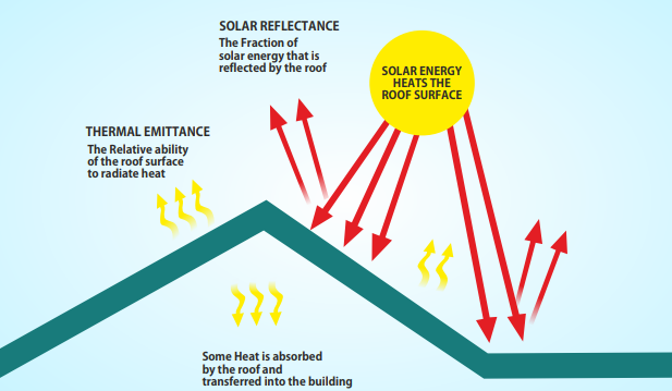
A Cool roof takes in less heat from sun than regular roofs. It stays relatively cool in the sun by reflecting (minimize solar absorption) and emitting thermal radiation (to help dissipate solar heat gain).
Cool roofs reflect around 80% of sunlight while regular roofs reflect only about 20%, keeping buildings significantly cooler.
Cool Roof techniques
Cool roof techniques can be broadly divided into three categories:
Coated Cool Roofs: These roofs involve the coating of a material or paint with high reflectivity on top of a conventional roof material to increase the roof surface's Solar Reflective Index (SRI). These are liquid applied coatings made of simple materials white in colour. Ex. Lime wash, Acrylic polymer, Plastic technology.
Membrane Cool Roofs: These roofs involve using pre-fabricated materials like membranes or sheeting to cover an existing roof to increase the roof surface's solar reflectance and thermal emittance. Ex. Polyvinyl chloride, bitumen based.
Tiled Cool Roofs: These roofs involve the application of high albedo, ceramic mosaic tiles or shingles on top of an existing roof or to a new roof.
Green roofs and rooftop solar systems: Policy also supports application of Green Roofs and Rooftop Solar Systems. Green Roofs make use of vegetation to help the roof absorb less solar energy by providing a thermal mass layer to reduce flow of heat into a building. Vegetation is especially helpful in reflecting infrared radiation.
Minimum Requirements Cool Roof Materials: For qualifying as a cool roof, roofs with slopes less than 20o shall have an initial solar reflectance of no less than 0.70 and initial emittance no less than 0.75.
Application of Policy
Mandatory cool roofing: Government, Non-residential & Commercial Buildings, Residential buildings with plot area more than 600 sq yards and Government assisted housing constructions.
Optional cool roofing: All other buildings
Benefits of Cool Roofs
Increased thermal comfort: Cool roofs can help keep indoor temperatures 2.1-4.3oC lower than households with traditional roofs.
Climate freindly cooling solution: Cool roofs are estimated to reduce air conditioning costs by 20% of the building leading to saving of cost and electricity and lower greenhouse gas emissions.
Limited maintenance and costs: Cool roofs need minimal maintenance and a cool protective coating can be reapplied periodically. Often initial material costs for cool roofs are comparable with traditional roofing materials and can also be applied on existing buildings.
Longevity of roof: Application of cool roof increases the longevity of roof beneath it, by acting as a protective layer.
Address Urban Heat Island Effect:City-wide installations of highly reflective roofs and pavements along with planting shade trees, has potential to reduce city’s ambient air temperature by 2oC in summer month. Thus, reducing urban heat island effect.
Equitable solution to heat stress for poor and low-income households: Heats stress hits the poor the hardest due to lack of access to cooling and their houses are often made of heat-trapping materials such as tin sheets, asbestos, plastic or tarpaulin without sufficient ventilation leading to health hazards and reduced productivity. Cool roofs are especially relevant to provide thermal comfort to poor & low-income households.
Other Initiatives for Cool Roofs
Million Cool Roofs Challenge:It is an initiative launched by Sustainable Energy for All (SEforAll) and NESTA Challenges in 2019 which awarded $125,000 in grants to 10 finalist teams based in South Africa, Bangladesh, Ivory Coast, Philippines, Indonesia, Kenya, Mexico, Niger, Rwanda & Senegal. In less than two years, collectevily the 10 countries managed to apply more than 1.1 million sq. m. of cool roofs.
Cool Roof Challenge: National Disaster Management Authority (NDMA) had launched inviting cities to announce targets and implement cool roofs in 2021.
Heat Wave Vulnerability In India
Heatwave
A heatwave is an extended period of hot weather relative to expected conditions of the area at that time of year.
Heat wave has emerged as one of the deadliest natural hazards often causing more deaths than all other natural hazards.
Heat waves have a slow onset and are silent killers unlike other disasters.
Greenhouse has emissions led Climate change has increased Earth’s temperatures by close to 1.10oC. Each year earth’s temperature cross previous limits.
Meteorological events like La Nina and El Nino also cause localised warming and cooling of planet. In the Indian context, El-Nino particularly increases chances of heat waves in the Indian subcontinent.
Urban Heat Island effect: This is a phenomena under which urban and suburban areas experience elevated temperatures compared to their outlying rural surroundings. The annual mean air temperature of a city with one million or more people can be 1 to 3°C warmer than its surroundings, and on a clear, calm night, this temperature difference can be as much as 12°C. Heat Island effect leads to increased heat risk in cities. Reasons for Heat Island effect are: Air Pollution which traps heat, concretisation & blackening of surfaces which traps heat.
Large and informal workforce of India makes India particularly vulnerable to heat waves who often work in less ventilated buildings or in the outdoors.
IMD Criteria for Heatwaves:IMD declares a heatwave when:
Temperature of a place crosses 40oC in the plains, 37oC in coastal areas and 30oC in the hills.
Temperature of a place is 4.5-6.4oC more than the normal temperature for the region on that day.
Temperature of a place crosses 4.5oC.
Way forward for Heat Wave
All States to formulate & implement Heat Action Plans in line with NDMA’s guidelines on Heat Wave.
Need to strengthen existing Early Warning Systems.
Need for understanding the local thresholds of Heat Wave.
Data on Heat: Automatic Weather Stations networks needs to be expanded in cities and states.
Vulnerability analysis: A comprehensive, country-wide assessment of heat vulnerability and hyper-local heat action plans is required.
Heat waves should be notified as disasters at the national level under existing disaster relief policies. Currently, several states have declared heat waves as a local disaster. Ex. Odisha, Maharashtra etc.
Land use change: Promoting Urban forests/farms, community gardens, rejuvenation of wetlands and shading of areas with trees.
Building materials: Promoting Green roofs and other materials that increase albedo, LEED compliant green building architecture, Home insulation. These solutions should be made part of building codes and effectively enforced.
Heat related work standards should be notified by Ministry of Labour and public health institutes to make workers work easily in high heat situations.
Provisions for Emergency: First Aid Kits, Drills for Heat Waves, Heat Wards in Hospitals etc.
Long Term solutions: Green Transition, Limiting Emissions and controlling climate change.
Context: In the recent meeting of the National Security Advisors of India and Russia, the possibility of joint development of the hypersonic version of BrahMos or BrahMos-II missile was discussed.
Hypersonic Weapon Systems (HWS)
Hypersonic weapon systems are advanced military technologies that can travel at extremely high speeds, typically defined as Mach 5 or higher (five times the speed of sound).
These weapons are designed to be extremely manoeuvrable, able to change course quickly during flight and evade enemy defence systems.
They are different from ballistic missiles, which can also travel at hypersonic speeds (of at least Mach 5) but have set trajectories and limited manoeuvrability.
There are two main categories of hypersonic weapons: hypersonic glide vehicles and hypersonic cruise missiles.
Hypersonic glide vehicles are launched from a rocket. The glide vehicle then separates from the rocket and “glides” at speeds of at least Mach 5 toward a target.
Hypersonic cruise missiles are powered by high-speed, air-breathing engines.
HWS are capable of carrying out launches from a variety of platforms, including ground-based systems, aircraft, and submarines.
They are typically designed to carry conventional or nuclear warheads and are seen as a potential game-changer in military operations, particularly in terms of their speed, range, and ability to penetrate enemy defences.
The United States, Russia and China are developing hypersonic weapons.
BrahMos-II Missile
BrahMos-II is a hypersonic cruise missile currently under joint development by India's Defence Research and Development Organisation and Russia's NPO Mashinostroyenia, which have together formed BrahMos Aerospace Private Limited.
BrahMos-II is expected to be capable of travelling at speeds of over Mach 7 (possibly reaching Mach 8) and has a range of around 620 miles (1000 kms).
It is being designed to be launched from multiple platforms, including land, air, and sea.
It is likely to have the same characteristics as Russia's Tsircon missile.
Key Facts
India is a party to the Missile Technology Control Regime (MTCR), which allows the country to develop a missile with a range of over 300 km and weighing more than 500 kg but not to export it to other countries.
The export version of BrahMos is capped at 290 km to comply with the MTCR restrictions of 300 km.
Context: After several years of efforts to gather seeds from all over the city and other states, a "seed bank," which gathers and stores seeds of species of plants that are native to the Aravallis, is gradually taking shape at a nursery at the Asola Bhatti Wildlife Sanctuary.
More about news:
It began in 2015 to provide saplings that are native to the city and bring back species that are now difficult to find in the city.
The project being implemented jointly by the Forest Department and the Bombay Natural History Society (BNHS).
For this project, seeds have been drawn from parts of Delhi, Rajasthan, Madhya Pradesh, Uttar Pradesh, Uttarakhand, Haryana, and Bihar.
Species that are specific to the Aravallis are identified by studying model sites that have intact forests with very little disturbance, like Mangar Bani in Faridabad. Efforts are then made to replicate these old-growth forests.
Among the additions to the seed bank are seeds of trees like salai and phalsa- species that are difficult to find in Delhi. These seeds were brought from Rajasthan and Haryana.
About Asola Bhatti Wildlife Sanctuary
Location
It covers area on the Southern Delhi Ridge of Aravalli hill range on Delhi-Haryana border lies in Southern Delhi as well as northern parts of Faridabad and Gurugram districts of Haryana state.
It is the part of the Northern Aravalli leopard wildlife corridor, an important wildlife corridor which starts from the Sariska National Park in Rajasthan, passes through Faridabad and Gurugram districts of Haryana and ends at Delhi Ridge.
Fauna
This is an important habitat for the Indian leopard, blackbuck striped hyena, jungle cat, golden jackal, Indian hare, Indian boar, black buck, sambar deer, spotted deer and hog deer among others. Endangered species in the sanctuary include red-headed vulture and egyptian vulture. Near-threatened species include painted stork, white-faced ibis and european roller.
Indian Seed Vault
It is a secure seed bank located in a high-altitude mountain pass on the Chang La in Ladakh, India.
It was built in 2010 jointly by the Defence Institute of High-Altitude Research and the National Bureau of Plant Genetic Resources.
Context: New research published in the journal Nature, has found that rapidly melting Antarctic ice is dramatically slowing down the flow of water through the world’s oceans, and could have a disastrous impact on global climate, the marine food chain and even the stability of ice shelves.
What is overturning circulation?
The “overturning circulation” of the oceans, driven by the movement of denser water towards the sea floor, helps deliver heat, carbon, oxygen and vital nutrients around the globe.
Ocean overturning allows nutrients to rise up from the bottom.
What the study found
As temperatures rise, freshwater from Antarctica’s melting ice enters the ocean, reducing the salinity and density of the surface water and diminishing that downward flow to the sea’s bottom.
According to a study, deep ocean water flows from the Antarctic could decline by 40% by 2050.
Disrupting the base of the food chain: The slow flow of water near Antarctica will slow down the whole circulation and will reduce the number of nutrients that get returned from the deep ocean back up to the surface.
Leaving more CO2 in the atmosphere: The ocean would not be able to absorb as much carbon dioxide as its upper layers become more stratified, leaving more CO2 in the atmosphere.
The study showed that warm water intrusions in the western Antarctican ice shelf would increase.
About Antarctica
Definition of Antarctica: All the Land and ice shelves to the south of 60-degree latitude.
Antarctica Treaty
It was signed in Washington on 1 December 1959 by the twelve countries whose scientists had been active in and around Antarctica during the International Geophysical Year (IGY) of 1957-58.
It entered into force in 1961 and has since been acceded to by many other nations.
The total number of Parties to the Treaty is now 56 (Including India).
Provisions:
Antarctica should be used only for peaceful purposes. No country should build military bases.
Freedom of scientific investigation in Antarctica.
No country should claim sovereignty over Antarctica based on setting up of Research stations.
No Nuclear explosions or disposal of radioactive wastes
Countries to take appropriate efforts to abide by the provisions of the treaty.
India and Antarctica:
India signed the Antarctic Treaty in 1983.
India ratified the Convention on the Conservation of Antarctic Marine Living Resources in 1985.
India signed Protocol on Environmental Protection to the Antarctic Treaty in 1998. (Madrid Protocol)
India's research stations in Antarctica: Dakshin Gangotri (De-commissioned now); Maitri and Bharati. Managed by National Centre for Polar and Ocean
Research (NCPOR), Goa under the Ministry of Earth Sciences.
Nov 2021: India launched its 41st Scientific Expedition to Antarctica.
Context: The Forest (Conservation) Amendment Bill, introduced in the Indian Parliament, proposes changes that will undermine the landmark Godavarman judgment of 1996, which has provided the basis for forest conservation in India for over 27 years.
Proposed changes to Forest Conservation Act
The proposed amendments seek to limit the applicability of the Forest Conservation Act, potentially allowing non-forest activities on over one-third of Aravalis in Gurgaon and Faridabad districts.
It would also exempt certain land parcels from prior approval requirements for non-forest use, including linear rail and road networks and land parcels not recorded as forest in government records.
The proposal suggests exempting specific types of lands from the Act in order to expedite the implementation of national strategic and security-related projects.
It also empowers the central government to specify, by order, the terms and conditions subject to which any survey, such as, reconnaissance, prospecting, investigation or exploration including seismic survey, shall not be treated as non-forest purpose.
Godavarman Judgement 1996
Supreme Court passed an interim order directing that tree-felling and non-forestry activity in forests across the country be stopped.
The path-breaking order re-defined the meaning of forests and extended protection to all areas with natural forests irrespective of their ownership.
It laid down that ‘forests’ will be understood by its dictionary meaning, and the provisions of the Forest (Conservation) Act 1980, shall apply to all thickly wooded areas.
States were directed to form expert committees to identify forests as defined and file reports.
Forest Conservation Act 1980
It was passed in India in 1980 to protect forests and wildlife.
The act regulates the use of forest land for non-forestry purposes, such as mining, industry, and construction.
Any diversion of forest land for non-forestry purposes requires prior approval from the central government.
The act establishes a National Committee for the Protection of Forests and Wildlife to advise the government on forest conservation and wildlife protection.
The act provides guidelines for compensatory afforestation, meaning that if any forest land is diverted for non-forestry purposes, an equivalent area of land should be reforested.
Forest in India
Forest Survey of India (FSI), Dehradun, an organization under the Ministry carries out the assessment of forest cover of the country biennially since 1987 and the findings are published in India State of Forest Report (ISFR).
The forest cover assessment is a wall – to – wall mapping exercise based on remote sensing supported by intensive ground verification and field data from National Forest Inventory.
As per latest ISFR 2021, the total forest cover of the country is 7,13,789 square kilometre which is 21.71% of the geographical area of the country.
The current assessment shows that the total forest cover of the country has increasedby1540 square kilometre, tree cover has increased by 721 square kilometre and total forest and tree cover has increased by 2261 square kilometre at the national level as compared to the previous assessment i.e. ISFR 2019.
Efforts to increase forest cover
National Mission for Green India (GIM)
To increase the forest cover in the country, afforestation programmes are taken up under various Centrally Sponsored Schemes of the Ministry such as National Mission for a Green India (GIM).
It is one of the eight Missions outlined under the National Action Plan on Climate Change.
It aims at protecting, restoring and enhancing India’s forest cover and responding to Climate Change by undertaking plantation activities in the forest and non- forest areas.
Nagar Van Yojana (NVY)
The Ministry of Environment, Forests & Climate Change is implementing NVY since the year 2020 which envisages developing 400 Nagar Vans and 200 Nagar Vatika in the country during the period of 2020-21 to 2024-25.
Its objective is to significantly enhance the tree outside forests and green cover, enhancement of biodiversity and ecological benefits to the urban and peri-urban areas apart from improving quality of life of city dwellers with the funds under the National Fund of the Compensatory Afforestation Fund Management and Planning Authority (CAMPA).
Afforestation activities are also taken up under various programmes/funding sources such as Mahatma Gandhi National Rural Employment Guarantee Scheme, Compensatory Afforestation Funds under Compensatory Afforestation Fund Management and Planning Authority (CAMPA). In addition, plantations are also done by various departments, Non-Government Organizations, Civil Society, Corporate bodies etc.
Context - An event in Goa aimed at recreating “the traditional Chinese sky lantern festival” by releasing candle-lit paper lanterns into the sky has sparked outrage among environmentalists and wildlife conservationists because it was due to be held at a beach near a nesting site of the endangered Olive Ridley turtles.
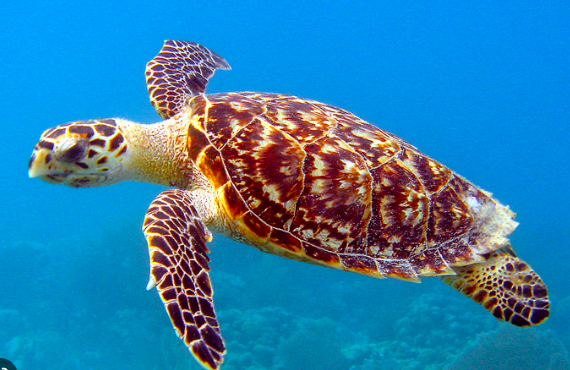
Olive Ridley
The Olive ridley turtles are the smallest and most abundant of all sea turtles found in the world, inhabiting warm waters of the Pacific, Atlantic and Indian oceans.
These turtles are carnivores and get their name from their olive coloured carapace.
They are best known for their unique mass nesting called Arribada, where thousands of females come together on the same beach to lay eggs.
The olive ridley turtles turn up in millions for mass nesting along the Odisha coast every year namely at three river mouths: Dhamara, Devi and Rushikulya.
Gahirmatha beach off Bay of Bengal coast in Kendrapara district is acclaimed as the world’s largest nesting ground of these turtles.
It extends from Dhamra River mouth in the north to Brahmani river mouth in the south.
The wetland is represented by 3 Protected Areas, the Bhitarkanika National Park, the Bhitarkanika Wildlife Sanctuary and the Gahirmatha Marine Sanctuary.
The species is listed as Vulnerable in the IUCN Red List, Appendix 1 in CITES, and Schedule 1 in Wildlife Protection Act, 1972.
They are extensively poached for their meat, shell and leather, and their eggs.
However, the most severe threat they face is the accidental killing through entanglement in trawl nets and gill nets due to uncontrolled fishing during their mating season around nesting beaches. In recent times, plastic pollution has also emerged as one of the greates threats to these creatures.
To reduce accidental killing in India, the Odisha government has made it mandatory for trawls to use Turtle Excluder Devices (TEDs), a net specially designed with an exit cover which allows the turtles to escape while retaining the catch.
Brahmani – Baitarni Delta
The basin consisting of Brahmani and Baitarni extends over states of Odisha, Jharkhand and Chhattisgarh having an area of 51,822 Sq.km. The basin is bounded by the Chhotanagpur Plateau on the north, by the ridge separating it from Mahanadi basin on the west and the south and by the Bay of Bengal on the east. The lower reaches of this basin near the deltaic area are subject to floods. Since Mahanadi, Brahmani and Baitarani are interconnected near their delta, worst flood occur when there is simultaneous heavy rains in all the three catchments. Prolonged submergence and breaching of embankments are common occurrences during floods. Floods are also caused from cyclonic storms since the coastal areas of the basin are cyclone prone.
Bhitarkanika national park is situated at the mouth of Brahmani, Baitarni and Dhamra rivers which is famous for saltwater crocodiles. Dense mangrove forests are found here. There also lies Gahirmatha beach and Gahirmatha wildlife sanctuary which is world’s largest ground for Olive Ridley Turtles.
Marine Turtles
Five species of sea turtles are known to inhabit Indian coastal waters and islands.
Olive Ridley turtle
Green turtle
Hawksbill turtle
Loggerhead turtle
Leatherback turtle
Except the Loggerhead, the remaining four species nest along the Indian coast.
Difference between Tortoise and Turtle
All tortoises are in fact turtles—that is, they belong to the order Testudines or Chelonia, reptiles having bodies encased in a bony shell—but not all turtles are tortoises.
Turtle
Tortoise
It is aquatic and marine form
They are exclusively on land
Comparatively smaller in size
Larger
Some turtles are fish eaters
They are herbivorous and feed entirely on vegetation
Their head is partially withdrawn into the shell
It can be completely withdrawn into the shell
Turtles have thinner, more water-dynamic shells. Turtle shells are more streamlined to aid in swimming.
Tortoises have more rounded and domed shells
Turtles will have more flipper like legs, or webbed feet to make it easier to cruise through the water.
Tortoises have club-like forelegs and 'elephantine' hind legs. Because tortoise are often larger and heavier, their elephantine hind legs help them move around and carry the extra weight
Context: Indian National Centre for Ocean Information Services (INCOIS) has carried out coastal vulnerability assessment for entire Indian coast at states level to prepare a Coastal Vulnerability Index (CVI).
Coastal Ecosystem
The highly productive coastal zone, intermediate between land and sea, is very vulnerable to coastal hazards because of its dynamic nature.
The coastal ecosystem provides various ecosystem goods and services for human well-being and the livelihood of coastal communities.
Due to their productivity, coastal zones are also crucial for long-term global sustainability and economic development.
What is coastal vulnerability?
It is the identification of coastal resources at risk due to coastal hazards.
A coastal hazard is defined as the occurrence of a phenomenon (e.g., a tropical storm/Sea level rise/Tsunami etc.), which has the potential for causing damage to, or loss of, natural ecosystems, buildings, and infrastructures.
Climate change poses a serious threat to the physical, economic, and social systems of the coastal environment.
Unprecedented pressure from population growth and development activities has had a negative impact on natural coastal phenomena.
In tropical countries, the coastal zone is constantly affected by cyclonic activities and storm surges, resulting in coastal erosion, inundation, and seawater intrusion, which has greatly increased the vulnerability of the coastal environments.
Environmental degradation, loss of mangroves, land conversion for shrimp farming, and other developmental activities have also increased coastal vulnerability to natural and anthropogenic hazards.
Short term vulnerability: Due to Cyclone / Storm surge/ Tsunami / Flash rain Flooding / Earthquake in the coastal area etc.
Long term vulnerability: Due to Sea level rise (SLR) / Ocean acidification / Coastal land subsidence etc.
Vulnerability of the Indian coastline
India has a 7500-km-long coastline with nine states and four union territories are highly susceptible to climate change.
About 35% of the Indian Population live within 100 km from the shoreline.
Most of the coastal areas are low lying and vulnerable to Oceanogenic disasters such as Tsunamis, Storm Surges, Sea-level rise.
Dec 26, 2004, Tsunami resulted in a loss of 18,045 deaths and 6,47,599 persons displaced.
Increased frequency and intensity of the disasters (Uttarakhand flood 2013, Phailin Cyclone 2013.
About Coastal Vulnerability Index
It is a quantitative tool that combines physical and socioeconomic indicators to evaluate how vulnerable coastal areas are to the effects of climate change, including but not limited to sea level rise, storm surges, and erosion.
INCOIS has prepared the Coastal Vulnerability Index (CVI) maps for the entire coastline of India to assess the probable implications of sea-level rise along the Indian coast.
It was established as an autonomous body in 1999 under the Ministry of Earth Sciences (MoES) and is a unit of the Earth System Science Organisation (ESSO).
It is mandated to provide the best possible ocean information and advisory services to society, industry, government agencies and the scientific community through sustained ocean observations.
Its mission it to provide ocean data, information and advisory services to society, industry, the government and the scientific community through systematic and focused research in information management and ocean modelling.
Context - In the last few years, there has been a concerted push from policymakers in India to transition to a circular economy and to, among other things, enable effective waste management. But waste management in the solar photovoltaic (PV) sector still lacks clear directives.
What is PV waste?
It is the electronic waste (e-waste) generated by discarded solar panels and Photo-voltaic (PV) devices.
Photovoltaic (PV) devices contain semiconducting materials that convert sunlight into electrical energy.
A single PV device is known as a cell, and these cells are connected together in chains to form larger units known as modules or panels.
Although up to 90% of the components are recyclable, many PV modules contain heavy metals such as cadmium, copper, lead, antimony or selenium, and when they are taken out of service or broken, they may be classified as hazardous waste.
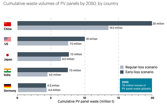
While photovoltaics generate only about 3 percent of global electricity, they consume 40 percent of the world’s tellurium, 15 percent of the world’s silver, a substantial chunk of semiconductor-grade quartz and lesser amounts of indium, zinc, tin and gallium. A report, prepared jointly by the International Renewable Energy Agency (IRENA) and the International Energy Agency Photovoltaic Power Systems Programme (IEA-PVPS) highlights that recycling or repurposing solar PV panels at the end of their roughly 30-year lifetime can unlock an estimated stock of 78 million tonnes of raw materials and other valuable components globally by 2050. If fully injected back into the economy, the value of the recovered material could exceed USD 15 billion by 2050.
Present status of Solar PV waste in India
According to a report prepared by the National Solar Energy Federation of India, India could generate over 34,600 tonnes of cumulative solar waste in India by 2030.
India currently considers solar waste a part of electronic waste and does not account for it separately. Moreover, there is no commercial raw material recovery facility for solar e-waste operational in India.
A committee had been constituted under the chairmanship of the Ministry’s Secretary to propose an action plan to evolve a “circular economy” in solar panel, through reuse/recycling of waste generated.
Challenges in India
Informal handling - Only about 20% of the waste is recovered in general; the rest is treated informally. As a result, the waste often accumulates at landfills, which pollute the surroundings. Incinerating the encapsulant also releases sulphur dioxide, hydrogen fluoride, and hydrogen cyanide into the atmosphere.
No segregation – PV waste is clubbed with e-waste in India generally.
High cost of recycling - Recycling a solar panel cost between $20 and $30, according to the National Renewable Energy Laboratory; sending it to a landfill costs $1-2.
Lack of incentives - The market to repurpose or reuse recycled PV waste is minuscule in India due to a lack of suitable incentives and schemes in which businesses can invest.
What can we do about them?
Promote recycling - According to a 2021 report, approximately 50% of the total materials can be recovered. The domestic development of PV waste recycling technologies must be promoted through appropriate infrastructure facilities and adequate funding. New business models, incentives or issues of green certificates to be provided to encourage the recycling industry to participate more.
Environmental disposal and recycling of solar waste could be part of the power purchase agreement SECI / DISCOMS / government signs with project developers.
Dedicated Policy formulation - India should formulate and implement provisions specific to PV waste treatment within the ambit of the e-waste guidelines. EPR for the manufacturer and developers to take responsibility for end-of-life the solar panel.
Ban on Landfills: Solar panel waste is harmful to the environment as it contains toxic metals and minerals that may seep in the ground.
Central insurance or a regulatory body should be set up to protect against financial losses incurred in waste collection and treatment.
Research and Development: Innovation in design may have an impact on the type of waste they generate; technology advancements will be significant in reducing the impact of renewable energy waste. New panels, for example, use less silicon and produce less waste during the manufacturing process.
Awareness drives - Pan India sensitisation drives and awareness programmes on PV waste management will be beneficial.
Global best practices
Europe - EU imposes responsibility for the disposal of waste on the manufacturers or distributors who introduce or install such equipment for the first time.UK - PV producers will need to register and submit data related to products used for the residential solar market (B2C) and non-residential market.
Australia - announced a $2 million grant as part of the National Product Stewardship Investment Fund to develop and implement an industry-led product stewardship scheme for PV systems.
Context - An Australian renewable energy company’s unique Scheme to generate electricity may resuscitate the fortunes of one of India’s iconic but defunct gold mines, namely the Kolar Gold Fields (KGF), in Karnataka.
How do Gravity Batteries work?
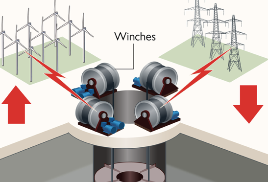
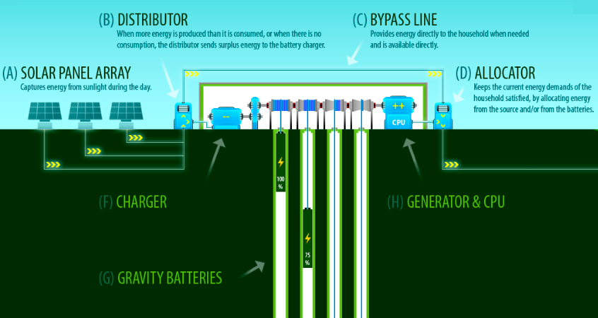
When there is plenty of green energy, the batteries use the power to lift a heavy weight either high into the air or to the top of a deep shaft.
Then when the renewables are limited, winches gradually lower the weight, release the load, powering a generator with the downward gravitational pull from the movement of the cables.
This would mean you could store power captured by a solar farm during the day when the sun is shining, and then release that electricity to the grid in the evening when demand rises because people are at home using electricity to watch TV, cook and heat their homes.
Gravity batteries vs Lithium-ion
Gravity batteries are not the only way renewable energy can be stored, lithium-ion batteries dominate the market, and some experts favour green hydrogen. But gravity is free, clean and easily accessible, without the complications of producing hydrogen or the environmental and human rights concerns linked to some lithium mining.
Storing power in mineshafts
Full-scale energy stores in former mines can make good use of existing infrastructure and create jobs in exactly those areas where they’re most needed. The emotional aspect of this is also important. Whole communities once worked in the mines - and generally, they’re very happy to see them used for storing renewable energy.”
Note - The World Economic Forum founded the Global Battery Alliance (GBA) in 2017 to establish a sustainable battery supply chain by 2030. The body of over 100 leading international organizations, NGOs, industry actors, academics and multiple governments became independent in 2021 and its membership is collectively working towards the goals set out in the GBA 2030 Vision. The GBA 2030 Vision is to foster a circular, responsible and just battery value chain.
The GBA hosts Action Partnerships to achieve its vision of a sustainable battery value chain by 2030, including:
The Battery Passport Action Partnership: to establish global criteria, data and benchmarks for a sustainable and transparent battery market;
Critical Materials: to ensure critical materials are sourced, processed, manufactured and recycled in a manner that minimizes environmental impacts, protects human rights and creates benefits for stakeholders along the value chain.
Energy Access & Circularity: to ensure energy access in emerging economies, reduce lead poisoning and promote circularity.
Context: The Union Enviornment Ministry and National Tiger Conservation Authority(NTCA) have recently decided to re-examine the entire aspect of translocation of Asiatic lions from Gir to Kuno from an expert’s perspective”.
About Asiatic Lion
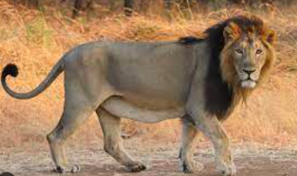
The Asiatic lion, also known as the Indian lion or Persian lion, is a population of Panthera leo leo that currently survives in the wild only in India.
Habitat: They live in a compact tract of dry deciduous forest and open grassy scrublands.
Distribution (subheading)
Historically, it inhabited much of the Middle East to northern India.
Since the turn of the 20th century, its range has been restricted to Gir National Park and the surrounding areas in the Indian state of Gujarat.
Characteristics
They are slightly smaller than African lions.
The most striking morphological character is a longitudinal fold of skin running along the belly.
The colour of their fur varies from buffish-grey with occasional silvery tones, to ruddy-tawny, covered with black spots.
Conservation Status
IUCN Red List: Endangered
CITES: Appendix I
Wildlife (Protection) Act 1972: Schedule I
State Animal of Gujarat
About Gir National Park
Location: Gir is a dry deciduous forest ecosystem in the Saurashtra region of Gujarat. It is the abode of the last surviving population of the free ranging Asiatic Lion
Flora: It consists of teak with an admixture of deciduous trees, including sal, dhak, and thorn forests.
Context: National Aluminium Company Limited (NALCO) has successfully developed a Bauxite Certified Reference Material (CRM) naming as BARC B1201 in joint collaboration with Bhabha Atomic Research Centre (BARC).
About BARC B1201
It is a bauxite-certified reference material (CRM).
It is the first-of-its-kind CRM in India and the fifth in the world.
What is a Certified Reference Material (CRM)?
CRMs are blocks of metal that come with certificates indicating the concentration of their various constituent elements along with their uncertainty levels.
Testing laboratories use CRMs to calibrate measuring instruments, evaluate test procedures and for quality control purposes.
About National Aluminium Company Limited (NALCO)
It is a Navratna Central Public Sector Enterprises CPSE, under Ministry of Mines, Govt. of India.
It is country’s leading manufacturer and exporter of alumina and aluminium.
What is Bauxite?
It is a sedimentary rock with a relatively high aluminium content.
Almost all of the aluminum that has ever been produced has been extracted from bauxite.
It does not have a specific composition. It is a mixture of hydrous aluminium oxides, aluminium hydroxides, clay minerals, and insoluble materials such as quartz, hematite, magnetite, siderite, and goethite.
How bauxite is formed?
Bauxite is formed by the thorough weathering of many different rocks. Bauxite may grade into laterite or clay, laterally or vertically.
Bauxite Used for Aluminum Production
The first step is to crush the bauxite and purify it using the Bayer Process.
Bayer Process:
In this the bauxite is washed in a hot solution of sodium hydroxide, which leaches aluminum from the bauxite.
The aluminum is precipitated out of solution in the form of aluminum hydroxide, Al(OH)3.
The aluminum hydroxide is then calcined to form alumina, Al2O3.
Aluminum is smelted from the alumina using the Hall-Heroult Process
In the Hall-Heroult Process, the alumina is dissolved in a molten bath of cryolite (Na3AlF6).
Molten aluminum is removed from the solution by electrolysis. This process uses an enormous amount of electricity.
Production and reserves
In India, Odisha alone accounts for 53% of the country’s resources of bauxite, and it is also found in the states of Andhra Pradesh, Jharkhand, Madhya Pradesh and Maharashtra.
Australia is the largest producer of bauxite, followed by Guinea and China.