Context: According to the Moroccan Interior Ministry, a massive earthquake that struck central Morocco has resulted in at least 2,122 deaths and 2,421 injuries. Most affected province and cities are Al Haouz province and Taroudant, Agadir, Al Hoceima (Mediterranean port city).
About Morocco
It is a country in the Maghreb Region of Western North Africa that lies directly across the Strait of Gibraltar from Spain.
The Atlas Mountains dominate the central part of the country, while the Rif Mountains make up the northern edge.
The Imperial Cities of Morocco are the four historical capital cities of Morocco: Fez, Marrakesh, Meknes, and Rabat. Rabat is the current capital of Morocco.
Jebel Toubkal is the highest point in Morocco and is also the highest peak of the Atlas Mountains.
The southeastern region of the country is blanketed by the Sahara Desert, the world's third-largest desert.
It is bordered by the two countries of Western Sahara to the south and Algeria to the east. It has coastlines on the Atlantic Ocean to the west and the Mediterranean Sea to the north.
Berbers or the Berber peoples, also called by their contemporary self-name Amazigh or Imazighen, are a diverse grouping of distinct ethnic groups indigenous to Morocco.
Most of Morocco north of Western Sahara, particularly along the coasts, experiences a typical Mediterranean climate, with mild wet winters and hot dry summers.
A Moroccan traveler, Ibn Battuta (1333-1347 AD) visited India during the reign of Muhammad-bin-Tughlaq.
With its acquisition of Western Sahara, Morocco came to possess some two-thirds of the world’s reserves of phosphates, used for the manufacture of fertilizers and other products.
Cause of earthquake in Morocco
This area is situated along the boundary of the African and Eurasian tectonic plates, where these massive plates interact, leading to the possibility of seismic activity.
Earthquakes in this region result from the northward convergence of the African plate towards the Eurasian plate along a complex plate boundary.
In the case of a particular earthquake in this area, oblique-reverse faulting occurs at shallow depths within the Moroccan High Atlas Mountain range.
North Africa typically experiences infrequent seismic events, resulting in minimal preparedness. The construction of buildings in this region tends to be compact and often does not adhere to earthquake-resistant construction standards.
Context: U.K. Prime Minister recently backed plans for new fossil fuel drilling off Britain’s coast.
About North Sea
North Sea, shallow, northeastern arm of the Atlantic Ocean, located between the British Isles and the mainland of northwestern Europe.
The sea is bordered by the island of Great Britain to the southwest and west, the Orkney and Shetland islands to the northwest,Norway to the northeast, Denmark to the east,Germany and the Netherlands to the southeast, and Belgium and France to the south.
It is connected to the Atlantic by the Strait of Dover and the English Channel and opens directly onto the ocean between the Orkney and Shetland islands and between the Shetland Islands and Norway.
The Skagerrak, an eastward extension of the North Sea between Norway and Denmark, connects the North and Baltic seas via the Kattegat and the Danish straits.
The North Sea waters are affected by the warm North Atlantic Current, which moves northward along the western side of the British Isles and enters the Norwegian Sea.
The North Sea has long been important as one of Europe’s most productive fisheries.
It also serves as a prominent shipping zone among European countries and between Europe and the Middle East.
The extensive reserves of petroleum and natural gas have been discovered beneath the seafloor.
Context:Amazon Summit under the aegis of the Amazon Cooperation Treaty Organisation (ACTO) came to an in the Belem City of Brazil. The Summit produced an outcome document known as Belem Declaration. This is only the fourth summit-level meeting under ACTO.
Amazon Cooperation Treaty Organisation (ACTO)
Amazon Cooperation Treaty Organisation (ACTO) is an intergovernmental organisation formed by 8 Amazonian countries: Bolivia, Brazil, Colombia, Ecuador, Guyana, Peru, Suriname and Venezuela (8 countries).
The above Eight nations decided to create ACTO to strengthen and implement under the Amazon Cooperation Treaty in 1995 to strengthen and implement the Amazon Cooperation Treaty objectives.
Permanent Secretariat of ACTO was established in Brasilia in 2002 and permanently installed in 2003. Permanent Secretariat of ACTO is to facilitate the exchange, knowledge, cooperation and joint projection among ACTO Member Countries to fulfil the mandate of Amazon Cooperation Treaty.
Amazon Cooperation Treaty was signed in 1978 to promote the harmonious development of Amazonian territories in a way that joint actions of Amazonian countries produce equitable and mutually beneficial results in achieving the sustainable development of Amazon region.
Objectives of Amazon Cooperation Treaty Organisation
Facilitate exchange and cooperation among Member countries, promoting strategic sustainable development and livelihoods with emphasis on vulnerable populations, indigenous people and other tribal communities.
Ensure that the interests and sovereignty of Member Countries are respected and promoted.
Promote the management of Amazonian resources in harmony with nature and the environment.
Promote and disseminate the culture of Amazon and foster respect and protection of ancestral and current wisdom.
Promote coordination of plans for Member Countries for the development of Amazonian populations.
About Amazon River and its Basin
Amazon region makes up more than half of the world's tropical rainforest and is the world's largest tropical forest. The region stretches over an area twice the size of India. Two-thirds of it lies in Brazil and the remaining is shared by other 7 countries and one territory (French Suriname). The region also has a significant presence of savanna-like biogeography.
Amazon River: Largest & longest river on Earth. It originates at 5597 metres in the Peruvian Andes on the slopes of the Quehuisha volcano.
Important tributaries of Amazon: Putumayo, Japurá and Negro River (north slope), Juruá, Purús, Madeira, Tapajós and Xingú.
Rich in biodiversity: Amazon's tropical forest biome accounts for 50% of Earth's existing biodiversity and is the most extensive and biodiversity-rich jungle on the planet.
Climatic significance of Amazon: Amazon has a great influence on heat & water vapour transportation to higher latitude regions.
Regulates regional climate
Regulates carbon absorption contributing to mitigating climate change.
Regulates evapotranspiration process
Cultural significance: Amazon basin is home to about 40 million inhabitants and is home to 400 indigenous peoples who speak more than 300 languages.
Challenges to Amazon Ecosystem
Deforestation and land use changes in Amazon Region.
Oil exploration in Amazon region and other mineral exploration.
Countries of the Amazon region aim for economic development.
Scientists believe when 20-25% of Amazon's rainforest is destroyed, rainfall will dramatically decline
Exploitation of rights of indigenous people in the Amazonian region.
Expansion of agricultural cultivation in Amazon region.
Organised crime and drug trafficking in Amazon region
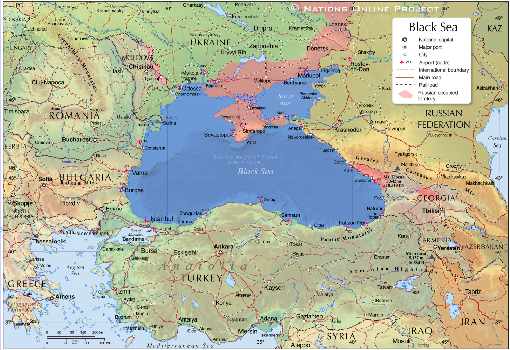
Context: Ukraine said its sea drones struck a major Russian port Friday and damaged a warship in an attack that underlined Kyiv’s growing capabilities as the Black Sea becomes an increasingly important battleground in the war.
Where is Black Sea Located?
It is a large inland sea situated at the south-eastern extremity of Europe.
It is bordered by Ukraine to the north, Russia to the northeast, Georgia to the east, Turkey to the south, and Bulgaria and Romania to the west.
It is connected to the distant waters of the Atlantic Ocean by the Bosporus (which emerges from the sea’s southwestern corner), the Sea of Marmara, the Dardanelles, the Aegean Sea, and the Mediterranean Sea.
The Crimean Peninsula thrusts into the Black Sea from the north, and just to its east the narrow Kerch Strait links the sea to the smaller Sea of Azov.
Several large rivers flow into the Black Sea, such as the Danube, the Dnieper, the Dniester, the Southern Bug, the Russian Don and the Kuban rivers, Western Georgia's Rioni river, and the Turkish Kızılırmak and Sakarya rivers.
The Black Sea is connected to the North Sea via the Danube and the Rhine-Main-Danube Canal.
How Black Sea was formed?
Large-scale movements of the Earth's crust uplifted the mountain ranges that divided the ancient Tethys Ocean into several water basins, such as the Paratethys Ocean. The megalake of the late Miocene was probably the largest lake in Earth's history and extended from the region east of the Alps across Central Europe to Central Asia. Its remnants include the Black Sea, the Sea of Azov, the Caspian Sea and the Aral Sea.
During the last great ice age, which ended about 25,000 years ago, the Black Sea was a large freshwater lake. The Bosphorus, the connection to the Mediterranean Sea - and to saline water - was presumably formed about 6,500 to 7,500 years ago.
The Black Sea has experienced the worst environmental degradation of all of the world's oceans. The situation has become so severe that it has affected the health, well-being, and standard of living of the people in the immediate area
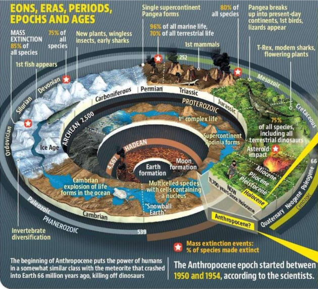
Context:A group of scientists have identified a small lake in Canada as the ground zero for ‘Anthropocene’.
What is Anthropocene?
It is an unofficial unit of geologic time which is used to denote the most recent period in Earth’s history when human activity started to have a significant impact on the planet’s climate and ecosystems, especially since the onset of the Industrial Revolution.
Neither the International Commission on Stratigraphy (ICS) nor the International Union of Geological Sciences (IUGS) has officially approved the term as a recognised subdivision of geologic time.
This term was first coined by Nobel Prize – winning chemist Paul Crutzen and biology professor Eugene Stoermer.
The phenomena’s which are associated with this geological time are global warming, sea-level rise, ocean acidification, mass-scale soil erosion, heat waves, deterioration of the biosphere and other detrimental changes in the environment.
Context: The Arctic Ocean could be ice-free in summer by the 2030s, even if we do a good job of reducing emissions between now and then. That’s the worrying conclusion of a new study in Nature Communications.
Over the past 30 years, the Arctic has warmed at roughly twice the rate as the entire globe, a phenomenon known as Arctic amplification. Most scientists agree that this rapid warming is a signal of human-caused climate change.
This map shows trends in mean surface air temperature over the period 1960 to 2019. Notice that the Arctic is red, indicating that the trend over this 60-year period is for an increase in air temperature of nearly 4° C (7.2° F) across much of the Arctic, which is larger than for other parts of the globe.
Multiyear ice:
The ice which remains at the end of summer is called multiyear sea ice and is considerably thicker than its seasonal counterpart. It acts as barrier to the transfer of both moisture and heat between the ocean and atmosphere. Over the past 40 years this multiyear sea ice has shrunk from around 7 million sq. km to 4 million.
Blue ocean event:
“Blue ocean event” is defined as when the sea ice area drops below 1 million sq. km. This threshold is used mainly because older, thicker ice along parts of Canada and northern Greenland is expected to remain long after the rest of the Arctic Ocean is ice-free. We can’t put an exact date on the last blue ocean event, but one in the near future would likely mean open water at the North Pole for the first time in thousands of years.
Reasons behind Arctic Amplification:
Change in Albedo:
When bright and reflective ice (with more albedo) melts, it gives way to a darker ocean (lowering albedo); this amplifies the warming trend because the ocean surface absorbs more heat from the Sun than the surface of snow and ice.
Currents are changing because more melting ice is injecting the Arctic Ocean with freshwater. The missing ice also exposes the surface waters to more wind. This mixes up colder freshwater at the surface and warmer saltwater below, raising surface temperatures and further melting ice.
Changing Weather
Ocean currents drive the powerful polar jet stream, which moves hot and cold air masses around the Northern Hemisphere. This is a product of the temperature differences between the Arctic and the tropics.
But as the Arctic warms, the jet stream now undulates wildly north and south. This has been injecting the Arctic with warm air.
The abundance of thunderstorms in tropics creates a near-constant flow of heat away from the tropics towards the Arctic.
Change in nature of Ice Cover
Quality of ice cover in the Arctic region is changing. New ice is replacing old ice.
Old ice is more resilient than new ice, which melts faster. New ice contains more salty water and is more subject to melting, whereas old ice has a higher share of water coming from snow precipitations and is a source of freshwater.
Impacts of Arctic Melting:
Coastal erosion: Over the Arctic Ocean, sea ice absorbs the impacts of waves and limits shoreline wave erosion. As sea ice retreats farther away from surrounding landmasses, late-summer and autumn storms stir up strong waves that crash onto shore.
Increase in sea level:Increased wave action caused due to sea ice melt can bend the ice shelves increasing the possibility of glacial retreat. Glaciers that have lost their ice fronts tend to flow faster, and because this process introduces a body of ice into the ocean that was not there previously, it raises sea level which further can lead to coastal flooding.
Global warming: Sea ice loss leads to increased permafrost thaw, which drives the release of carbon dioxide and methane—an even more potent greenhouse gas.The retreat of sea ice exposes greater expanses of darker ocean water, which absorbs more solar radiation than white sea ice, perpetuating the global warming effect.
Alteration of ocean current: Massive amounts of very cold glacial-melt water entering warmer ocean waters reduces the thermal contrast between cold and warm waters. It further alters the density differences also thereby leading to slowing down of ocean currents.
Changes in weather systems: accelerating sea ice melt could be linked to the intensification of Central Pacific trade winds, the emergence of El Niño events, and a weakening of the North Pacific Aleutian Low Circulation — a semi-permanent low pressure system that drives post-tropical cyclones and generates strong storms.
Loss of biodiversity: Arctic melting is disrupting the behavior of marine mammals and ice-obligate species including polar bears, walruses, and bearded and ringed seals. Restructured food webs, changes in prey populations, the arrival of new marine mammal species (including new predators and competitors), and pathogens from more temperate seas will challenge Arctic species.
Higher human interference: The loss of Arctic Sea ice could open up new regions to shipping, tourism, and oil extraction. More people living, working, and extracting resources in the Arctic will likely require more infrastructure, and may raise the risk of emergencies needing cleanup or rescue.
About 5.9 Million Tonnes of Lithium Reserves have been discovered in the Union Territory of Jammu and Kashmir (First in India). It is discovered in the Salal-Haimana area of Reasi District.
Lithium Distribution:
Although lithium is widely distributed on Earth, it does not naturally occur in elemental form due to its high reactivity.
According to the US Geological Survey (USGS), there are around 80 million tonnes of identified reserves globally as of 2019.
Argentina, Bolivia, and Chile make up the “lithium triangle.” The three countries, along with Peru, contain about 67% of proven lithium reserves and produce about half of the global supply, according to the U.S. Geological Survey.
The Salar de Uyuni salt flat in Bolivia is the world's single-largest lithium resource, and is visible from space
Physical and Chemical properties of Lithium (atomic number 3)
It belongs to an alkali metal group, lightest of the solid elements (can float on water). It is soft, white and lustrous.
It has the lowest density of any metal.
It has high specific heat which is the calorific capacity. Other properties are its enormous temperature interval in the liquid state, high thermal conductivity.
It is also found in brine deposits and as salts in mineral springs.
It constitutes about 0.002 percent of Earth’s crust.
It is produced by electrolysis of a fused mixture of lithium and potassium chlorides.
Uses and application of Lithium:
Among minerals, lithium offers one of the highest energy-to-weight performance—a lithium-ion battery’s energy density is 260-270 Wh/kg, compared to a lead-acid battery’s 50-100 Wh/kg.
Used as a scavenger (remover of impurities) in the refining of such metals as iron, nickel, copper, and zinc and their alloys.
Used as an initiator of polymerization in the production of synthetic rubber.
It is also extensively used in the production of other organic chemicals, especially pharmaceuticals
Lightweight lithium-magnesium alloys and tough lithium-aluminium alloys, harder than aluminium alone, have structural applications in the aerospace and other industries.
Most extensive use of Lithium is in rechargeable batteries (cell phones, laptops, e-mobility etc).
Note: lithium-ion batteries are rechargeable while lithium batteries are single-use.
Benefits of such discovery to India;
Decrease imports: As of now, India is importing all its lithium requirements (95% coming from Hong Kong > China > Indonesia > Singapore > Korea).
Save foreign exchange: In the near future imports would fall further (saving foreign exchange).In last three years, imports of Lithium and Lithium ion has reduced by 8-10%.
Employment: Mining and exploration would further enhance the job creation in the reserve areas.
Industrial hub: It would developed battery industry (a sunrise sector) in India.
Exports: With development of battery industry, India could enter the global supply of lithium ion batteries (export promotion). It would help India in gaining faster momentum in the electronics and digital devices market globally.
Reduce production cost: Replacing expensive imports of lithium with domestic cheaper alternatives would reduce the cost of production in battery industry and make it more competitive.
Potential of Lithium in India:
Expected reserves in: Union Territory of Jammu and Kashmir, Mandya and Yadgir districts of Karnataka, Bihar, Chhattisgarh, Himachal Pradesh, Jharkhand, Madhya Pradesh, Arunachal Pradesh, Meghalaya and Rajasthan.
India has emerged as one of the largest producer, consumer and exporter of mobiles phones (second largest producer in 2021). Lithium ion batteries are the backbone of mobile phone industries. Domestic lithium would push India further ahead in this race.
Government in 2021 approved the Production Linked Incentive (PLI) Scheme for manufacturing of Advance Chemistry Cell (ACC) in the country. The scheme envisages establishing a competitive ACC battery manufacturing set-up in the country (50 Giga Watt hour-GWh). This PLI scheme will facilitate reduction of import dependence of ACC battery.
Vikram Sarabhai Space Centre (VSSC) has decided to transfer its own in-house lithium ion (Li ion) cell technology to successful Indian industries and start-ups.
The government has allowed 100 percent foreign direct investment (FDI) in electric mobility and encouraged domestic manufacturing of battery packs. Due to this measure, LiB technology has overtaken lead-acid batteries in mobile and stationary applications.
Why is India lagging behind in Lithium?
Natural availability of Lithium in India is the least (almost insignificant)
Research and exploration in the lithium is at nascent stage.
India has very limited participation in the exploration of lithium. Most of the current exploration of Lithium is conducted as per the Geological survey of India.
Till 2021, i.e. rolling out of production linked incentive, there was no dedicated policy for lithium battery development in India.
Way-forward:
Creation of additional demand in the automobile sector.
Opening the exploration and mining for the private sector under regulatory framework.