Astronomy & Space Technology

What next for ISRO after Chandrayaan-3 mission?

Context: The Indian Space Research Organisation (ISRO) has a packed schedule after Chandrayaan-3 as it is working on various missions. 

Upcoming missions of ISRO: 

  1. ADITYA-L1 Mission: Aditya-L1 is the first Indian space mission to observe the Sun and the solar corona. It would observe:

  i. Sun’s Photosphere
  ii. Chromosphere and
  iii. Corona

  • The mission will be launched to the L1 orbit (which is the first Lagrangian point of the Sun-Earth system), which is 1.5 million km from the Earth towards the Sun.
  • Aditya-L1 has seven payloads in total, of which the primary payload is the Visible Emission Line Coronagraph (VELC).
    • VELC is designed and fabricated by the Indian Institute of Astrophysics, Bengaluru.
    • It is a solar coronagraph that can image the solar corona as close to the solar disk (It can image it as close as 1.05 times the solar radius).
    • It can also do imaging, spectroscopy, and polarimetry at the same time, and can take observations at a very high resolution, or level of detail, and many times a second.
image 110
  • Significance:
    • Aditya-L1 would help in understanding the effect of the Sun on the Earth and its surroundings.
    • It would study solar upper atmosphericdynamics (chromosphere and corona) and understand the physics of the solar corona and its heating mechanism.
      • The temperature of the Sun's corona is extremely high, ranging from 1 to 3 million kelvins (K). This is much hotter than the Sun's surface, which has a temperature of about 5,500 K.
      • To understand this issue, it will capture near-simultaneous photos of the many layers of the Sun's atmosphere, revealing how energy is routed and transported from one layer to the next.
    • It would help in understanding the phenomenon of coronal mass ejection, pre-flare and flare activities, dynamics of space weather, propagation of particles and fields etc. This would help in tracking Earth-directed storms and predicting their impact through solar observations. 
  1. X-ray Polarimeter Satellite: XpoSat is an ISRO-planned space observatory to study the polarisation of cosmic X-rays. It is India’s first dedicated polarimetry mission to study the dynamics of bright astronomical X-ray sources under extreme conditions. 
image 111
  • Payloads: The spacecraft will carry two scientific payloads – an X-Ray Polarimeter (POLIX) and X-ray SPECtroscopy and Timing (XSPECT) in a low earth orbit. 
  • POLIX will measure the polarimetry parameters (degree and angle of polarization) in the medium X-ray energy range of 8-30 keV photons of astronomical origin. POLIX is expected to observe about 40 bright astronomical sources of different categories during the planned lifetime of the XPoSat mission of about 5 years. 
  • XSPECT payload will give spectroscopic information in the energy range of 0.8-15 keV. It would observe several types of sources viz. X-ray pulsars, blackhole binaries, low-magnetic field neutron stars in Low-mass X-ray binaries, Active galactic nuclei and Magnetars. 
  • Significance: 
    • By measuring the polarisation of X-rays, astronomers can better understand the geometry and physical processes responsible for X-ray emission in a variety of astrophysical sources to gain insight into their inner dynamics (like emission processes).
      • Astronomical sources, including black holes, neutron stars, active galactic nuclei, and pulsar wind nebulae, present complex emission mechanisms that challenge their current understanding. 
      • By combining polarimetric observations along with spectroscopic and timing measurements, researchers can overcome the limitations of the present understanding of astronomical emission processes. 
  1. NISAR: NASA-ISRO Synthetic Aperture Radar is an Earth-observation satellite expected to be launched in January 2024 from Satish Dhawan Space Centre in Andhra Pradesh into a sun-synchronous orbit. 
  • The 2,800 kilograms satellite consists of both L-band and S-band synthetic aperture radar (SAR) instruments, which makes it a dual-frequency imaging radar satellite. SAR is capable of penetrating clouds and can collect data day and night regardless of the weather conditions. 
  • L-band SAR operates at a frequency of around 1 to 2 GHz. The lower frequency (higher wavelength) of L-band SAR allows it to penetrate through vegetation and soil, making it useful for monitoring changes in forest cover, soil moisture etc.
  • S-band SAR operates at a frequency of around 2 to 4 GHz. S-band SAR has a higher resolution than L-band SAR and is typically used for applications where higher detail is required, such as monitoring changes in urban areas or coastal zones. 
  • It has a large 39-foot stationary antenna reflector made of a gold-plated wire mesh which will be used to focus the radar signals emitted and received by the upward-facing feed on the instrument structure. The instrument’s imaging swath allows it to image the entire Earth in 12 days.
  • Jointly developed by: ISRO and NASA
image 112

Significance:

  • NISAR satellite with two frequency bands: L-band and S-band will image the seismically active Himalayan region that will create a “deformation map” every 12 days and provide high-resolution all-weather data. 
  • Study Earth’s dynamic land and ice surfaces in greater detail and observe subtle changes in Earth’s surfaces. E.g., Track flow rates of glaciers and ice sheets, landslide-prone areas and changes in the coastline etc.
  • Spot warning signs of natural disasters, such as volcanic eruptions, earthquakes and landslides. 
  • Measure groundwater levels, map agricultural and natural resources and monitor Earth’s forest and agricultural regions to improve understanding of carbon exchange. 
  1. INSAT-3DS: ISRO has also lined up the launch of INSAT-3DS, an earth-observation satellite. INSAT–3DS will be placed in the geostationary orbit with coarse resolution and daily multiple imaging capability. It will provide meteorological services to India, as well as search and rescue information and message relays for terrestrial data collection platforms. The satellite will be a follow-up to INSAT-3DR.
  1. Test vehicle mission: Before undertaking the Gaganyaan human spaceflight mission, ISRO had planned for two uncrewed missions. The launch of a test vehicle mission, for the validation of the crew escape system for Gaganyaan, the country’s maiden human space flight mission, is planned for the beginning of 2024. 

GROWING ASTRONOMICAL INTEREST TOWARDS MOON

Context: India’s ISRO is launching Chandrayaan-3 mission to moon. However, along with ISRO other space faring nations are also planning mission towards moon. This article explores the reasons behind the same.

image 44

Moon

  • Moon is the only satellite of Earth. 
  • It is devoid of atmosphere and rotates. 
  • Moon revolves around the Earth in around the same time as Earth rotates on its axis.  
  • Tidal locking is a phenomenon by which a body has the same rotational period as its orbital period around a partner. Since, moon rotates the Earth at the same time as it takes to orbit Earth. Thus, we can see only one side of the moon.

Recent missions planned or executed for Moon

  • Chandrayaan-3 by India's ISRO which is equipped with lander and rover. 
  • Luna 25: Russia's moon lander mission scheduled in 2023.
  • Artemis Program of NASA (USA): Aims to send a manned mission to Moon by 2025.
  • China plans to send a manned mission to Moon by 2030.
  • SLIM Mission: It is small scale exploration mission by JAXA (Japan) designed for pinpoint landings on the Moon's surface, reduction in size and weight of equipment used in Moon landings and investigation into Moon's origins.
  • Ispace: It is a Japanese startup aiming to have a lander on Moon in 2023.
  • Private American aerospace companies Intuitive Machines and Astrobotic Technology each aim to place a lander on moon.
  • India has ratified the Artemis Accords which establishes a framework for cooperation in civil exploration and peaceful use of Moon, Mars and other astronomical objects. 

Reasons behind increased focus on Moon

  • Moon is being seen as a vital stepping-stone for interplanetary exploration.
  • Moon has presence of rare minerals and elements including titanium and helium-3 that could be used to build nuclear fusion plants.
  • Moon has presence of frozen water which can be harnessed for sustaining a population and agriculture. 
  • There is a race among nations to figure out how to get these precious resources and transport them to Earth.

Recent findings about Moon

Characteristics of far side of moon: 

  • Far side of the moon has a dramatically different landscape as compared to the face of moon visible from Earth. Far side has a thicker crust by almost 20 km. 
  • The far side of the moon is also more densely pockmarked, with millions of more asteroids and comets having crashed into this half. 
  • Far side of moon has almost no characteristic dark spots which are less reflective volcanic basalt plains. 

Water on Moon

  • Chandrayan-1 (India's first lunar mission) carried two instruments provided by NASA for surveying the poles of moon for possible traces of water ice. 
  • The instruments were (i) Moon Mineralogical Mapper - An infrared spectrometer & (ii) MiniSAR - Miniature Synthetic Aperture Radar.
  • These instruments gave a definitive proof of presence of water ice in more than 40 craters on the poles of moon indicating potential for life, for research stations or settlements, perhaps even crops.
  • Scientists believe that water is concentrated in the craters at the poles of moon because they don't receive any sunlight. On other parts of moon, a combination of low pressure and daytime temperatures of 120 degree celsius vaporises water.
  • However, in 2020 NASA's SOFIA Observatory found the first evidence of water on moon in a sunlit spot, indicating presence of water on the Moon was widely distributed. 

Moon's soil

  • Lunar soil, also known as regolith, contains a number of familiar elements such as iron, silicon, potassium, manganese and magnesium. However, it does not contain organic matter such as microbes and insects. 
  • Lunar soil is hydrophobic i.e., it repels rather than absorbs water. 
  • Lunar soil has been exposed to extremely unhealthy amounts of solar radiation. 
  • Last year, scientists on Earth succesfully grew plants in lunar soil brought back to Earth by NASA's Apollo missions in the 1970s. However, scientists found that plants in lunar soil were growing slower, had stunted roots and leaves and developed red spots. This was due to much higher exposure to salt or heavy metals. However, drought tolerant plants fared better in lunar soil.

Chandrayaan-3

Context: Indian Space Research Organisation (ISRO) plans to launch the Chandrayaan-3 mission, India’s third lunar mission, to the moon on July 14. 

Chandrayaan-3: 

  • Chandrayaan-3 is a follow-on mission to Chandrayaan-2 to demonstrate end-to-end capability in safe landing and roving on the lunar surface. 
  • It will be launched onboard a Launch Vehicle Mark 3 from Sriharikota, Andhra Pradesh. 
  • Cost of the mission: Rs 615 crore
  • Duration: The mission is only meant to last for a half lunar day, which is roughly equal to 14 Earth days. 
image 30

Objectives: 

  • To demonstrate a Safe and Soft Landing on Lunar Surface (near the lunar South Pole).
  • To demonstrate Rover roving on the moon (which will carry out in-situ chemical analysis of the lunar surface during the course of its mobility)
  • To conduct in-situ scientific experiments.
image 1

Soft-landing on Moon:

  • This will be India’s second attempt to soft-land a lander and rover on the lunar surface.
    • Chandrayaan-2 was launched in July 2019 in the form of an orbiter and a lander (‘Vikram’) bearing a rover (‘Pragyan’).
    • While the orbiter entered into orbit around the moon, the surface mission failed in September 2019 when the lander crashed instead of executing a slow descent.
  • Chandrayaan-3 consists of a Lander and a Rover similar to Chandrayaan-2, but would not have an orbiter.
    • The rocket (LVM-3) will place the payload in an elliptical orbit around the earth, where a propulsion module will take over and pilot the lander to a circular orbit around the moon.
    • Finally, the lander will detach and begin a series of manoeuvres culminating in a gradual landing (on August 23-24, 2023) over the surface of the moon.
  • To improve the chances of success at this stage, ISRO made changes to the software and hardware of the Chandrayaan-3 mission, especially for the lander thrusters. Additionally, ISRO has developed improved soft-landing sequences and the lander has four thruster engines instead of five, sturdier legs and larger solar panels, and will carry more fuel.

Several advanced technologies in Chandrayaan-3:

  • Propulsion module has a Spectro-polarimetry of Habitable Planet Earth (SHAPE) payload to gather data on the polarisation of light reflected by Earth so that researchers can look for other planets with similar signatures. Hence, it will assist with exoplanet searches. 
  • Lander payloads:
    • Chandra's Surface Thermophysical Experiment (ChaSTE) to measure thermal conductivity and temperature on the surface;
    • Instrument for Lunar Seismic Activity (ILSA) to detect moonquakes;
    • Langmuir Probe to estimate the density and variation of plasma, or superheated gas, in the moon's environment; 
    • A Laser Retroreflector Array (from NASA) to measure distances using laser ranging to understand the dynamics of the Moon system. 
  • Rover payloads:
    • Alpha Particle X-ray Spectrometer (APXS) to look for elements in the lunar soil and rocks;
    • Laser Induced Breakdown Spectroscope (LIBS) to examine the chemical and elemental composition of the lunar surface.

Significance of Chandrayaan-3:

  • Chandrayaan-3 offers opportunities for India to lead the world’s response to the moon’s growing importance in the scientific and political milieus.
    • Chandrayaan-3 is India’s second attempt to achieve a soft landing on the Moon’s surface. Only three countries – the United States, Russia and China – have successfully landed spacecraft on the airless lunar surface.
    • Chandrayaan-3 will be the first to land on the South Pole of the Moon. All other spacecraft which have landed on the moon have landed in the equatorial region, a few degree latitude north or south of the lunar equator. 

Why moon’s South Pole? 

  • Experts note that there is a possibility of the presence of water at the South Pole. Water ice has been detected at both poles of the Moon, but the South Pole has more area in permanent shadow and colder temperatures, so it is thought to have more water ice.
  • Moreover, the South Pole witnesses extremely cold temperatures; this means that anything trapped here would remain frozen in time, without undergoing much change. The rocks and soil in this region could therefore provide clues to the early solar system.

Further, South Pole is located in the South Pole-Aitken basin, which is a huge crater. There may be material from the deep crust and upper mantle of the Moon on or near the surface.

Giant Metrewave Radio Telescope (GMRT) 

Context: An international team of astronomers from India, Japan, and Europe has published the results from monitoring pulsars, called nature’s best clocks, by using six of the world’s most sensitive radio telescopes, including India’s largest telescope, the Pune-based Giant Metrewave Radio Telescope (GMRT) provides evidence confirming the presence of nano-hertz (ultra-low frequency) gravitational waves using pulsar observations.

Giant Metrewave Radio Telescope

About GMRT

  • It is a low-frequency radio telescope that helps investigate various radio astrophysical problems ranging from nearby solar systems to the edge of the observable universe. 
  • It is an array of thirty fully steerable parabolic radio telescopes of 45-metre diameter, observing at metre wavelengths. It is the largest and most sensitive radio telescope array in the world at low frequencies.
  • It is operated by the National Centre for Radio Astrophysics (NCRA), a part of the Tata Institute of Fundamental Research, Mumbai.
  • It is located near Narayangaon, Pune.
  • Astronomers from all over the world regularly use this telescope to observe many different astronomical objects such as HII regions, galaxies, pulsars, supernovae, and Sun and solar winds.
  • It was recently upgraded with new receivers, after which it is also known as the upgraded Giant Metrewave Radio Telescope (uGMRT).

About Pulsar

Pulsars are a type of rapidly rotating neutron stars that are essentially embers of dead stars which are present in our galaxy. It is like a cosmic lighthouse as it emits radio beams that flashes by the Earth regularly akin to a harbour lighthouse.

Euclid Space Telescope

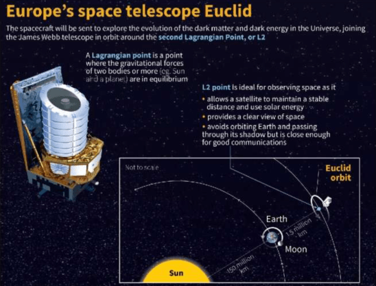
Context: The European Space Agency (ESA) plans to survey billions of galaxies using the Euclid Space Telescope, which is due to launch on July 1 from Cape Canaveral in Florida on a SpaceX Falcon 9 rocket.

Euclid Space Telescope

Euclid Mission:

  • The mission is part of ESA’s ‘Cosmic Vision’ programme which plans to explore the origin and components of the Universe and the laws that govern it.
  • The payload will have a 1.2 metre-wide telescope, a visible-wavelength camera (VISible) and a near-infrared camera/spectrometer (NISP).
    • VISible will look for tiny distortions in the shapes of distant galaxies from different points in time to understand the tussle between the pull of gravity and the push of dark energy.
    • NISP will look at how quickly galaxies are moving away from each other, offering scientists insights into the effects of gravity. 
  • Stationed 1.5 million km away from the Earth, the telescope is expected to deliver images at least four times sharper than ground-based observatories.
  • The Euclid mission hopes to understand the evolution of the Universe by looking at the light emitted from galaxies 10 billion years ago. Euclid's main objective is to better understand dark matter and dark energy, which together make up 95% of the universe.
U6CCR2tmEVj6fwvF73plkv9aNOnxzJriCsIBgfi0YEH Nq2hWMNsqDbfOhjli2NHHNG6hUxLs8pRam69jUneHUJS2kuqkiZAEGhmPD 3eUVdtJU6 DwBw8GtO4XSgWiOoHYnhncm6aCzHHPSMcJpg

Dark Energy:

  • Around 68% of the Universe is made of dark energy while dark matter makes up 27%. Only the remainder is composed of fermionic matter, i.e., things on the Earth, planets, stars, etc.
  • Scientists theorised the existence of dark energy 25 years ago when a team of researchers found that instead of slowing down due to gravity (inwards pulling force), the expansion of the Universe was speeding up. Scientists hypothesised that this was happening due to a mysterious form of energy called dark energy.
    • The expansion of the universe is accelerating. Previously it was thought that the pull of gravity will either slow down or even retract the expansion.
    • Dark energy has been hypothesised as a repulsive force — a sort of anti-gravity. As our universe is expanding, it indicates that Dark Energy has a greater abundance than dark matter.
  • Dark energy is a property of space so does not get diluted as space expands. As more space comes into existence, more of this energy-of-space appears. As a result, dark energy causes the universe to expand faster and faster.
  • While Dark matter exerts a “pull” on the universe, Dark Energy has a contrasting expansionary effect.
I5rxxNwqmiUUda8OhGSLwWOW07az9q8Q0L6hSzsSaZyGEmwErJEPTiuO r6vW FzYSoKqa8t2XbIdPl14VCLbEFrc4QvVSS7pwDl1LGG1C8J9t6YjM3m

Dark Matter:

  • Dark matter has not yet been observed directly. It does not interact with matter and is completely invisible to light and other forms of electromagnetic radiation making it impossible to detect.
  • Scientists are confident it exists because of the gravitational effects it has on galaxies and galaxy clusters.

India-Norway Space Cooperation

Context: Norwegian Ambassador’s visit to the Indian Space Research Organisation (ISRO) headquarters offers an occasion to recall the launch of Rohini RH-300 Mk-II, the challenging mission which took place 26 years ago at Ny-Alesund, Svalbard.

image 82

About Rohini RH-300 Mk-II

  • It is a single-stage sounding rocket, derived from French Belier rocket engine technology. 
  • It was part of the Rohini family of sounding rockets developed by ISRO’s Vikram Sarabhai Space Centre (VSSC) in Thiruvananthapuram.
  • It rose to the skies from Svalbard, Norway, an archipelago situated in the Arctic Ocean, operationalising a new rocket launching range there.

The RH-300 Mk-II was given a new name by the NSC (Norwegian Space Centre): Isbjorn-1, which translates literally as ‘Polar Bear-I.’

About Sounding Rocket

  • Sounding rockets are one or two-stage solid propellant rockets used for probing the upper atmospheric regions and for space research. 
  • They also serve as easily affordable platforms to test or prove prototypes of new components or subsystems intended for use in launch vehicles and satellites.
  • It is used for a variety of scientific purposes, including atmospheric research, astronomy, microgravity experiments, and space technology testing.
  • The first sounding rocket to be launched from Thumba was the American Nike-Apache in 1963. 

Geomagnetic storms and magnetosphere

Context: Researchers have traced a very significant increase in special continuous oscillations with pearl-type structures called Geomagnetic Pc1 pearl oscillations on the surface of the Earth in the recovery phase of geomagnetic storms. This study is significant for investigating of precipitation particles during geomagnetic storms and can help us understand the radiation hazard to satellites and astronauts.

What are geomagnetic storms?

  • A geomagnetic storm is a major disturbance of Earth's magnetosphere that occurs when there is a very efficient exchange of energy from the solar wind into the space environment surrounding Earth. 
  • These storms result from variations in the solar wind that produces major changes in the currents, plasmas, and fields in Earth’s magnetosphere. 
  • The solar wind conditions that are effective for creating geomagnetic storms:
    • Sustained (for several to many hours) periods of high-speed solar wind. 
    • Southward directed solar wind magnetic field (opposite the direction of Earth’s field) at the dayside of the magnetosphere. This condition is effective for transferring energy from the solar wind into Earth’s magnetosphere.
    • High-speed solar wind stream (HSS).
  • The largest storms that result from these conditions are associated with solar coronal mass ejections (CMEs) where a billion tons or so of plasma from the sun arrives at Earth. 
  • Storms also result in intense currents in the magnetosphere, changes in the radiation belts, and changes in the ionosphere, including heating the ionosphere and upper atmosphere region called the thermosphere. 

How Solar flares are formed?

How Solar flares are formed

Impacts of such storms:

Geomagnetic storms and magnetosphere
  • Increase in the density in the upper atmosphere, causing extra drag on satellites in low-earth orbit. 
  • Horizontal variations in the in the ionospheric density that can modify the path of radio signals and create errors in the positioning information provided by GPS. 
  • Storms create beautiful aurora. 
  • They also can disrupt navigation systems such as the Global Navigation Satellite System (GNSS).
  •  They can create harmful geomagnetic induced currents (GICs) in the power grid and pipelines.

What is Magnetosphere?

  • It is the region around a planet dominated by the planet's magnetic field. Other planets in our solar system have magnetospheres, but Earth has the strongest one of all the rocky planets.
  • Earth's magnetosphere is a vast, comet-shaped bubble, which shields our home planet from solar and cosmic particle radiation, as well as erosion of the atmosphere by the solar wind - the constant flow of charged particles streaming off the sun. 
  • It is generated by the convective motion of charged, molten iron, far below the surface in Earth's outer core. 
  • Constant bombardment by the solar wind compresses the sun-facing side of our magnetic field. The sun-facing side, or dayside, extends a distance of about six to 10 times the radius of the Earth. The side of the magnetosphere facing away from the sun - the nightside - stretches out into an immense magnetotail, which fluctuates in length and can measure hundreds of Earth radii, far past the moon's orbit at 60 Earth radii.

Difference between Ionosphere and Magnetosphere?

  • The ionosphere is a region within the upper mesosphere and thermosphere where solar radiation and particles in the "solar wind" strip electrons from atoms in the atmosphere and create an electrically charged zone of ions. It is used to communicate long distances by radio. Radio waves bounce off the ionosphere in much the same way that light is reflected by a mirror. The ionosphere changes its position from day to night, rising in the night and lowering in the day. This is why radio signals from far off places can be detected at night, while only close by transmissions are detectable during the day.
  • The magnetosphere is Contained within the Earth's thermosphere and is the region where the Earth’s magnetic field interacts with the charged particles coming from the Sun in the solar wind. These particles become trapped in the magnetic field of the Earth and circulate around the Earth following the Earth’s magnetic field. Large bombardments of these charged particles cause the auroras in the ionosphere as they follow the Earth’s magnetic field through the upper atmosphere towards the magnetic poles.

What are Van Allen radiation belts?

  • The Van Allen radiation belt is a zone of energetic charged particles, most of which originate from the solar wind. The particles are captured by and held around a planet by that planet’s magnetic field. It surrounds Earth, containing a nearly impenetrable barrier that prevents the fastest, most energetic electrons from reaching Earth.
  • The outer belt is made up of billions of high-energy particles that originate from the Sun and become trapped in Earth’s magnetic field, an area known as the magnetosphere. The inner belt results from interactions of cosmic rays with Earth’s atmosphere.
image 450

ISRO launches advanced navigation satellite NVS-01

Context: Indian Space Research Organisation (ISRO) successfully launched NVS-01 (a second-generation navigation satellite) on board the Geosynchronous Launch Vehicle from the Satish Dhawan Space Centre, Sriharikota, Andhra Pradesh.

What is new in the second-generation NavIC satellite?

  • NVS-01 is the first of the second-generation navigation satellites designed to sustain and augment the NavIC constellation with enhanced features. The 2232 kg satellite carries navigation payloads L1, L5, and S bands and an indigenously developed rubidium atomic clock to determine date and location. 
  • L1 signals for better use in wearable devices: The second-generation satellites will send signals in a third frequency, L1, besides the L5 and S frequency signals that the existing satellites provide, increasing interoperability with other satellite-based navigation systems.
    • NavIC system operates in the L5 band, which is a protected frequency specifically assigned to the Indian system. This dedicated frequency enhances the system's robustness and ensures minimal interference from other signals.
    • NVS-1 incorporates L1 band signalsadditionally to widen the services.
      • The L1 frequency is among the most commonly used in the Global Positioning System (GPS) and will increase the use of the regional navigation system in wearable devices and personal trackers that use low-power, single-frequency chips. 
  • Atomic Clock: The satellite will have a Rubidium atomic clock onboard, indigenously developed by Space Application Centre-Ahmedabad. Satellite-based positioning systems determine the location of objects by accurately measuring the time it takes for a signal to travel to and back from it using the atomic clocks on board. 
  • Longer mission life: The second-generation satellites will also have a longer mission life of more than 12 years. The existing satellites have a mission life of 10 years. 
image 446

About NavIC:

  • Navigation with Indian Constellation (NavIC), earlier known as Indian Regional Navigation Satellite System, is a satellite navigation system developed by the Indian Space Research Organisation (ISRO).

Objective: 

  • To provide independent satellite navigation services to the Indian region, reducing dependence on other global navigation systems like the Global Positioning System (GPS) or the Russian GLONASS.
  • To enhance the accuracy and reliability of positioning and timing services in various sectors, including transportation, disaster management, surveying, and agriculture.

Features:

  • NavIC consists of a constellation of seven satellites in geostationary and geosynchronous orbits around the Earth, namely, IRNSS-1A, IRNSS-1B, IRNSS-1C, IRNSS-1D, IRNSS-1E, IRNSS-1F, and IRNSS-1G.
    • NVS-01 will replace IRNSS-1G. 
  • It is designed to provide positioning, navigation, and timing services to users across India and the region extending up to 1,500 km around the country, with position accuracy of better than 20 meters, and timing accuracy of better than 50 nanoseconds. 
image 447

NavIC offers two types of services:

  1. Standard Positioning Service (SPS): Available to all users and provides positioning accuracy of around 20 meters throughout the Indian region and within the primary service area.
  2. Restricted Service (RS): Encrypted service primarily intended for authorised users such as the military, government agencies, and other security-sensitive applications. It provides higher accuracy and additional features compared to the SPS.

Applications:

  • Terrestrial, aerial, and marine navigation
  • Location-based services in mobile devices and marine fisheries 
  • Disaster management
  • Vehicle tracking and fleet management
  • Precise timing
  • Mapping and geodetic data capture
  • Terrestrial navigation aid for hikers and travellers
  • Visual and voice navigation for drivers
  • Precision agriculture

Advantages of having a regional navigation system:

  • NavIC provides coverage over the Indian landmass and up to a radius of 1,500 km around it.  Unlike GPS, NavIC uses satellites in high geo-stationery orbit — the satellites move at a constant speed relative to Earth, so they are always looking over the same region on Earth.
  • NavIC signals come to India at a 90-degree angle, making it easier for them to reach devices located even in hard-to-reach areas like congested areas, dense forests, or mountains. GPS signals are received over India at an angle.
  • With the use of NavIC picking up, the government has been looking at the possibility of increasing the coverage area of the system.
    • Work is underway to set up ground stations in Japan, France, and Russia. 
    • Once fully operational — with ground stations outside India for better triangulation of signals — NavIC open signals will be accurate up to 5 metres and restricted signals will be even more accurate. 

Satellite navigation systems of other countries:

  • There are four global satellite-based navigation systems.
    • United States: Global Position System (GPS)
    • Russia: GLONASS
    • China: BeiDou
    • European Union: Galileo

Japan has a four-satellite regional navigation system (Quasi-Zenith Satellite System).

StarBerrySense Star Sensor

Context: A new low-cost star sensor, developed by astronomers from the Indian Institute of Astrophysics (IIA) from off-the-shelf components, was recently put into space by ISRO’s PSLV C-55.

About the Star sensor:

  • Named ‘StarBerrySense’, the payload (sensor) is mounted on ISRO’s PSLV orbital experimental module (POEM), which provides a stable platform for our payload to operate from.
    • POEM is a unique initiative by ISRO that utilises the spent fourth stage of the PSLV rocket as an orbital platform for carrying out scientific experiments. 
  • Main function of StarBerrySense is to image the field of view, correctly identify the stars it sees, and accurately calculate where a satellite is pointing in space, as for any space mission it is crucial to know the exact positioning of the satellite. The start sensor is capable of finding its pointing direction in space by identifying the stars in its field of view.
  • This payload is built around the well-known minicomputer RaspberryPi, and the electronics and software were designed in-house. The advantage of this payload is that it is cost-effective, simple to build, and can be deployed on a wide variety of satellites. 
image 4

Star-sensor:

  • The star sensor is essentially a celestial compass. Any satellite needs to know where it is pointed in space, and the instrument used for this purpose is called a star sensor.
  • The position of stars in the sky is fixed relative to each other and can be used as a stable reference frame to calculate the orientation of a satellite in orbit. This is done by correctly identifying the stars in the sky towards which the star sensor is pointed. 

New space policy sets out roles of private and govt entities

Context: Indian Space Policy - 2023, which was approved by the Cabinet Committee on Security on April 6, was made public recently. 

About New India Space Policy 2023

(a) Role of Government entities:

  • Indian Space Research Organisation shall transition out from manufacturing operational space systems and focus its energies on research and development in new space technologies and applications and on expanding the human understanding of outer space.
  • Department of Space has been asked to implement the policy, interpret and clarify any ambiguities and establish a framework for safe and sustainable space operations and ensure that the different stakeholders are suitably empowered to discharge their respective functions without overlapping into the others' domains.
  • Indian National Space Promotion and Authorisation Centre (IN-SPACe) shall function as an autonomous government organization, mandated to promote, hand-hold, guide and authorise space activities in the country.
  • NewSpace India Limited (NSIL), as the public sector undertaking under the Department of Space, shall be responsible for commercialising space technologies and platforms created through public expenditure. The policy:
    • Mandated NSIL to manufacture, lease or procure space components, technologies, platforms and other assets from the private or the public sector on sound commercial principles.
    • Tasked NSIL to service the space-based needs of users, whether government entities or non-government entities, on sound commercial principles.

(b) Role of Private companies:

  • Private companies, referred to as non-governmental entities in the policy, will be allowed to undertake end-to-end space activity — launching and operating satellites, developing rockets, creating ground stations, building spaceports and mobile launch platforms, and providing services like communication, remote sensing and navigation, nationally and internationally.
  • Private entities have also been encouraged to develop space situational awareness capabilities — a mechanism to track objects in space and avoid collision of satellites and space stations with each other or space debris.
  • Private players can engage in the “commercial recovery” of asteroids or space resources. The companies will be entitled to “possess, own, transport, use, and sell” such resources in accordance with the law.

(c) Empower Indian Consumers:Indian consumers of space technology or services -- such as communication, remote sensing, data services and launch services - whether from the public or the private sector, shall be free to directly procure them from any source.

PSLV Orbital Experimental Module

Context: Indian Space Research Organisation (ISRO) is scheduled to launch the Polar Satellite Launch Vehicle C55 (PSLV-C55) mission on April 22 with Singapore’s TeLEOS-2 as the primary satellite and Lumelite-4 as a co-passenger satellite. 

  • PSLV-C55 mission has the PSLV Orbital Experimental Module (POEM), where the spent PS4 (fourth and final stage of the PSLV launch vehicle) would be utilised as an orbital platform to carry out scientific experiments through non-separating payloads. 
image 34

PSLV Orbital Experimental Module (POEM) 

  • PSLV Orbital Experimental Module is a platform that will help perform in-orbit experiments using the final, and otherwise discarded, stage of ISRO’s Polar Satellite Launch Vehicle (PSLV).
  • The PSLV is a four-stage rocket where the first three spent stages fall back into the ocean, and the final stage (PS4) — after launching the satellite into orbit — ends up as space junk. However, in the PSLV-C55 mission, the spent final stage will be utilised as a “stabilised platform” to perform experiments. 
  • POEM has a dedicated Navigation Guidance and Control (NGC) system for attitude stabilisation, which stands for controlling the orientation of any aerospace vehicle within permitted limits. The NGC will act as the platform’s brain to stabilize it with specified accuracy.
  • POEM will derive its power from solar panels mounted around the PS4 tank, and a Li-Ion battery. It will navigate using “four sun sensors, a magnetometer, gyros & NavIC”.

Detection of radio signals from YZ Ceti b

Context: Astronomers have detected a repeating radio signal from exoplanet YZ Ceti b suggesting the presence of a magnetic field — one of the prerequisites for a habitable planet — around it.

Major Highlights

  • YZ Ceti b is a rocky, earth-sized exoplanet rotating around a small red dwarf star, YZ Ceti, barely 12 light-years from Earth. 
  • Just as energy surges from the sun sometimes disrupt telecommunications on Earth and damage orbiting satellites, intense bursts of energy from the YZ Ceti star-exoplanet exchange produce spectacular auroral lights. This is seen indirectly in the form of the radio emission.
  • These radio waves, strong enough to be detected from Earth, confirmed the existence of an exoplanetary magnetic field. Such signals can only be produced if the exoplanet orbits very close to its parent star and has its own magnetic field to influence the stellar wind and generate the signals. 
  • Survival of a planet’s atmosphere may depend on its having, or not having, a strong magnetic field, since the field protects its atmosphere from being eroded by the charged particles from its star.

What is the magnetic field of YZ Ceti b?

The discovery of a repeating radio signal from YZ Ceti b suggests that the planet has a magnetic field. This is important because a magnetic field can help to protect a planet from harmful solar radiation. Scientists are still trying to learn more about the magnetic field of YZ Ceti b, and how it could impact the planet's habitability.

How did YZ Ceti b form?

YZ Ceti b is thought to have formed in the same way that Earth did, through the accretion of dust and gas around a young star. However, there are some key differences between the formation of YZ Ceti b and the formation of Earth. For example, YZ Ceti b is orbiting a much smaller star than Earth, and it is also much closer to its star. These factors could have had a significant impact on the way that YZ Ceti b formed, and on its eventual habitability.