MOVEMENT OF INDIAN PLATE

- Indo – Australian plate includes Peninsular India and Australian continental portions.
- Subduction zone along Himalayas forms northern plate boundary in the form of continent— continent convergence.
- In the east, it extends through Arakan yoma Mountains of Myanmar.
- Western margin follows Kirthar Mountain of Pakistan. It further extends along the Makrana coast and joins the spreading site from the Red Sea rift south eastward along the Chagos Archipelago.
- Boundary between Indo-Australian and Antarctic plate is also marked by oceanic ridge (divergent boundary)
- India was a large island situated off Australian coast, in a vast ocean. The Tethys Sea separated it from the Eursian continent till about 225 million years ago.
- India started her northward journey about 200 million years ago at the time when Pangaea broke. Tibetan block was closer to the Asiatic landmass.
- India collided with Eurasia about 40-50 Mn years ago causing rapid uplift of the Himalayas (Still rising).
PLATE TECTONICS & EAST AFRICAN RIFT VALLEY

East-African Rift Valley (EAR) is a developing divergent plate boundary in East Africa. Here, eastern portion of Africa, Somalian plate, is pulling away from rest of continent, which comprises Nubian plate. Numalian plates are also separating from Arabian plate in thus creating a ‘Y’ shaped rifting system.
PLATE TECTONICS & EARTHQUAKES
- Major tectonic events associated with plate boundaries are ruptures and faults along the constructive plate boundaries, faulting and folding along destructive plate boundaries and transform faults at conservative plate boundaries. All sorts of disequilibrium are caused due to different types of plate motions and consequently earthquakes of varying magnitudes are caused.
- At divergent boundaries, shallow foci (25-45 km) and moderate earthquakes occur because the rate of rupture of the crust and upwelling of lavas due to fissure is also slow. Ex. at mid-Atlantic ridge, mid Indian oceanic ridge and east pacific rise.
- At convergent boundaries, earthquakes of high magnitude and deep foci occur because of deeper subduction of one plate. Here mountain building, faulting and violent volcanic eruptions cause disastrous earthquake. Ex. Circum-Pacific Belt.
WORLD DISTRIBUTION OF EARTHQUAKES
Circum-Pacific Belt: Coastal Margins of North and South America and East Asia representing the margins of Pacific. 65% of the global Earthquakes occur in this region. It has ideal conditions of (i)C-O convergence and subduction zones, (ii)zone of young, folded mountains and (iii) zone of active volcanoes.
Mid-Atlantic Belt: Epicentres located along mid Atlantic ridge. Earthquakes are because of transform faults and fractures because of splitting of plates.
Mid-Continental Belt: Alpine-Himalayan belt representing collision of continental plates. 21% of global earthquakes occur in this region. They represent weaker zones of folded mountains and fault induced earthquakes.

INDIA’S DISTRIBUTION OF EARTHQUAKES
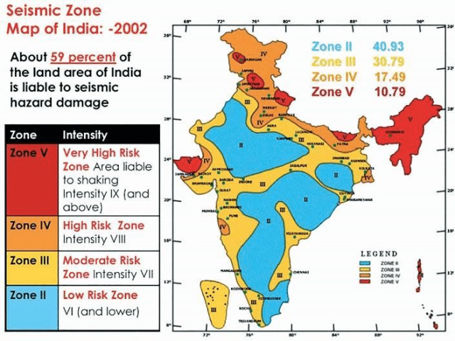
India been classified into different zones based on intensity of damage or frequency of earthquake occurrences.
11% in very high-risk zone V, 18% in high-risk zone IV and 30% moderate risk zone III. Capital cities of Guwahati and Srinagar are in seismic zone V, while national capital of Delhi is in zone IV and mega cities of Mumbai, Kolkata and Chennai are in zone III. 38 cities with population of half a million and above each and a combined population of million are in these three regions.

REASONS FOR HIGH SEISMICITY IN HIMALAYAS
- Active C-C convergence zone leading to continuous shaking of ground.
- ‘Double layering’ effect produces shallow foci earthquakes which strike the surface fastest.
- Region of young, folded mountains with sedimentary rock formations have weaker zones and numerous faults.
- Underlying stress been accumulated for over thousands of years when release their energy; produces tremors and vibrations.
- Steep slopes lead to frequent landslides in turn leading to earthquakes.
- Increasing human induced super incumbent load in form of roads, rails, buildings etc further destabilises the region.


